Guanajuato: A City for Flaneurs and Loiterers!
 2010 is a big year for Mexico!
I just completed another visit to Mexico, once again starting in Guadalajara, but then doing a 9-day driving trip through the heart of the country. This new year is Mexico's bicentennial and centennial (independence from Spain and the revolution, respectively), and signs denoting the historic routes of the country's history have sprouted up all over the place.
Our trip took us through a lot of the old colonial center of Mexico, with special mention for Patzcuaro and its surrounding region, and our amazing trip to the wintering grounds of the Monarch butterfly high in the Michoacan mountains. But for Streetsblog readers, there is a city in Mexico that is a must-see: Guanajuato!
 View down into the center of Guanajuato.
 We took a funicular down the hill into town, one of my favorite forms of transportation!
 This was the view westward from our funicular window.
I didn't know much about Guanajuato before I went, except that there were mummies there, and it was a former mining capital, built in the mountains. It was once a prosperous capital of the Spanish colony, and later during the dictatorship of Porfirio Diaz, it had a second glory period as the mines again became a source of great wealth. I learned a lot about the history of Mexican independence, which starts here in this region. The father of Mexican Independence, Miguel de Hidalgo, led about 80,000 farmers and miners to this city in 1810 to attack the Spanish authorities. He was captured a few months later and his head hung with some other rebels on the outside of the granary (today the same building is a great museum of Mexican Independence, well worth a visit). But years of guerrilla war ensued, and by 1823 Mexico was independent. Interesting to contextualize Mexican independence in the same period with the French Revolution, the Haitian revolution, and not long after the U.S. emerged from British colonialization; also, this region, Guanajuato-Bajio, was the economic powerhouse of Mexico in those times, so it's little wonder at the birth of capitalism that the successful merchants and mine owners would contribute to the political movement against colonization.
 Historic image of Guanajuato, from the Museum Alhondiga (the old granary, shaded in orange.
What I didn't know before going, and found breathtaking and inspiring, is that Guanajuato today is largely a city for pedestrians, flaneurs, and loiterers! It's a bustling Mexican city, but unlike most urban centers in our southern neighbor, the city was never bulldozed to make way for a modern street grid.
 It was the New Year weekend, but locals assured us it was common for the streets to be this jammed in Guanajuato.
Somehow, urban planners in the 1950s had the foresight to realize that the charming alleys, stairways, plazas, and narrow streets should be preserved and enhanced. Today, Guanajuato is a designated World Heritage Site by the United Nations, and it retains an incredible old-world charm, reminding me more of an Italian city than anything I'd previously known in Mexico (though on this trip I discovered Patzcuaro, another place that retains a good deal of its historic beauty and charm).
 Modest plazas are everywhere, and heavily used by locals.
 Gorgeous views everywhere of the beautifully painted homes adorning every stairway and alley.
 A walker's paradise!
There are almost 300 taxis rolling around, and tourists are strongly advised to avoid driving in to the city center. Because not only is the city a crazy, delightful labyrinth of alleys and stairways, with few thoroughfares for cars and even fewer places to park, but underneath the city is a surprising network of tunnels that seem to have a life of their own. Pedestrians walk in there, cars go through four-way intersections with barely a pause to just miss each other, and the urban ritual of waiting for parking places (precariously tucked into the side of the tunnel rights-of-way) can quickly back up traffic in the dimly lit subterranean tunnels.
 These cars are emerging from the subterranean tunnels. Such ramps appear suddenly and are well-used by locals. Not much place for cars to go once they emerge, though!
 A tunnel entrance.
 I wonder if anyone stays down here all day?
 A better shot of the tunnel's inside.
Starting in 1946, the local government began to refurbish the state college, and soon after embarked on an extensive effort at rehabilitation. Due to the city's location at the bottom of a canyon, it had been subject to flooding from time to time, being completely submerged in 1905 (signs everywhere indicate the level of inundation). The main river was in a tunnel under the city, but as part of the 1950s planning, a dam was built and the river diverted, opening the tunnel as a transit space. More tunnels were built during that decade and into the 1960s, so that the city above was preserved while cars were shunted below.
 This is the view across the city, back at the top of the funicular line on the opposite hill.
The cascading pastels and brightly painted homes that rise on either side of the city center are as delightful as the beautiful views across the steep valley that the intrepid walker earns on an ascent. But what took my breath away over and over again was the experience of turning a corner, or popping out of a stairway, and finding myself in one of what must be well over a hundred charming pedestrian-only plazas that seem to be everywhere. Guanajuato's residents clearly know how to enjoy city life together. Every possible corner and available space has been made into a plaza, usually with benches, trees, and often a fountain or a sculpture to anchor it.
 This is a plaza far up the hill in a residentail area with limited car access.
 It rained on us but we couldn't stop walking and marveling at the endless plazas!
 Nearer to the center, this one had a lovely fountain too...
 An extended sidewalk in front of a small market becomes a plaza too.
 We were going crazy with the reflections on the wet pavement and the colors, not all of which are adequately captured on camera, obviously!
One of my all-time favorite books, which I've probably mentioned here before, is Italo Calvino's "Invisible Cities," wherein he whimsically describes imaginary urban spaces full of improbable stairways, nooks and crannies, plazas, inside-out relationships between built and natural environments, and much more... Nothing is more fun than entering an unknown city and wandering until good and lost, and all the while discovering vistas and public spaces that one can only wonder about: just how amazing is it to live with this as part of your everyday existence? Visiting Guanajuato will inspire my imagination for the rest of my life!
Stay in touch
Sign up for our free newsletter
More from Streetsblog San Francisco
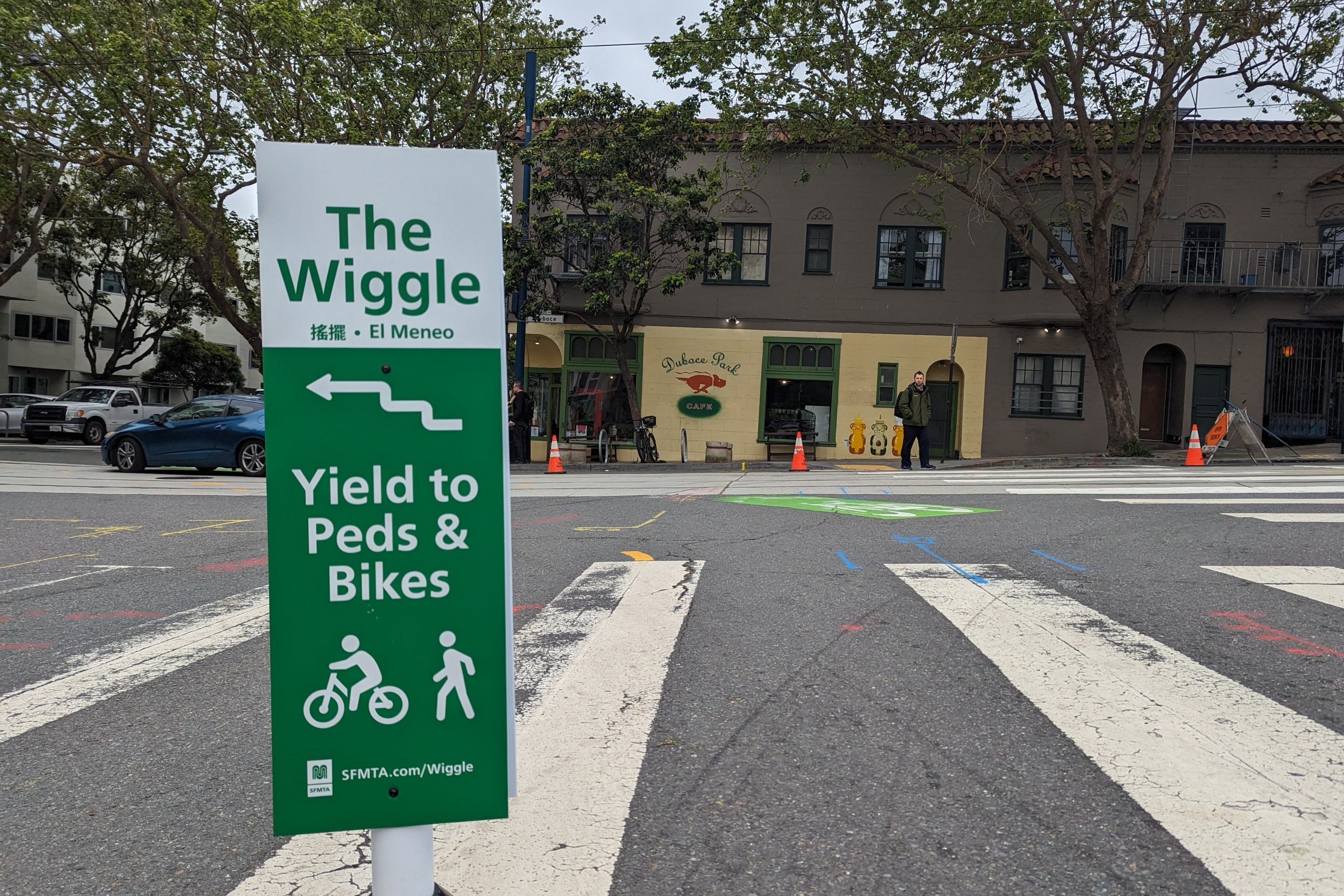
Independent Safety Advocates Beef up the Wiggle
Signs and soft-hit posts installed by advocates make the Wiggle bike route calmer and safer for cyclists and pedestrians