Planning Department Unveils San Francisco’s First Pedestrian Priority Street
 The proposed design for a single-surface pedestrian priority Jefferson Street
The City Design Group at the Planning Department has released its proposal for transforming Jefferson Street at Fisherman's Wharf into a single-surface pedestrian priority street, the first of its size in San Francisco.
Based on shared space or woonerfs, the plan calls for removing traditional traffic demarcations, such as the separation between streetbed and sidewalk, and slowing vehicle movement on the streets by making conditions less familiar for motorists. With 85,000 daily pedestrians and only 5,000 vehicles, 30 percent of which transportation conultants Nelson Nygaard estimated were cruising for parking or passing through, the proposal will use design elements to prioritize the street's majority users. High visibility pavers will be used to demarcate pedestrian "safe" zones beyond existing sidewalks, and trees, benches, and street furniture will break up the street and create loose divisions meant to exclude vehicles while encouraging pedestrians to use the whole street for crossing, strolling, or standing.
Planning project manager Neil Hrushoway said the proposal for the street treatments came from Danish consultant and livable streets icon Jan Gehl, whose firm Gehl Architects will soon release a detailed study and recommendations for improving the quality of the public realm throughout the Fisherman's Wharf area. "A single-surface street focuses on serving the needs of pedestrians without closing the street off to deliveries and other necessary trips to the area," Hrushowy said.

The community planning process for Jefferson Street began in 2006, when the Fisherman's Wharf Community Betterment District (FWCBD) was formed. After several community charettes, the FWCBD approached then Supervisor Aaron Peskin to get political and agency support for redesigning the streets around the waterfront destination, which sees 13 million annual visitors, the second largest tourist draw in California behind Disneyland. With 187 current members, the FWCBD has nurtured the process and sought to blunt criticism of the plans.
FWCBD director Karen Bell noted that Santa Monica, Long Beach, and Redwood City are already moving ahead with dynamic street designs and that San Francisco should balance its distinctive character with innovation.
"We don't want to lose our edginess as a wharf, but we don't want to be lost from history, either," she said.
Hrushowy noted that the initial concerns of area stakeholders, such as several restaurants on Taylor Street that were upset about parking and vehicular access to the 280 space garage nearby, were ameliorated with modifications to the design and clear communication about the commercial benefits of improving pedestrian amenities. Planning has spent the past few weeks meeting one-on-one with principals in the area, including the Argonaut Hotel, Budin, Alioto's, Pier 39, and Ghiradelli Square, answering questions and addressing concerns. The Port of San Francisco reported receiving largely positive feedback from merchants, property owners, and community partners.
Some merchants along Jefferson have complained about losing the 90 on-street parking spaces, spaces they insist are vital to their business, though data collection and anecdotal experience suggests that the merchants are often using the spaces for their own vehicles.
Because many of the design elements in the Jefferson Street vision are new for the city, agencies have tried to adapt their design standards for the innovative street. The Mayor's Office of Disabilities has been working with Lighthouse for the Blind and other disabilities advocacy groups to come up with solutions for visually impaired street users that meet ADA guidelines and also account for streets with less rigid divisions between elements. Central delineators, or slightly raised and beveled street pavers, such as those used successfully in the UK for similar shared streets, will likely define the boundary between pedestrian safe zones on the street and sections where cars will drive. A slightly raised curb will be installed beside the proposed streetcar lines once those are built.
Other treatments Planning hopes to implement are reduced speed limits of 5-10 mph, significantly lower than the minimum city speed limit of 25 mph, elimination of jaywalking regulations, and flexible traffic control devices like retractable bollards and gates.
Neal Patel of the SFBC said that every effort should be taken to restrict personal vehicle access to the street and that deliveries should be limited to particular times of day to assure that pedestrians and cyclists have primacy on the street.
Funding is still a problem. Planning estimates the 5 block project area will cost $10-12 million to complete, significantly more that the $800,000 to $1 million it would cost to grade and repave an equivalent section of street with no special treatments. Hrushowy said the money for the EIR would likely come from Planning itself, while he is hopeful that with the cooperation of the Port and the MTA, the city can find the necessary capital funds to complete the project by 2014. The FWCBD's Bell is optimistic that with public and private partnership, and diverse funding sources available to the many agencies involved, like Proposition K and stimulus funds, capital money will be secured.
 Jefferson and Taylor intersection shown with concessions to restaurants nearby that wanted to maintain street access
Stay in touch
Sign up for our free newsletter
More from Streetsblog San Francisco
Commentary: There is Zero Ambiguity to the West Portal Tragedy
What happened in West Portal was entirely predictable and preventable. The city must now close Ulloa to through traffic and make sure it can never happen again

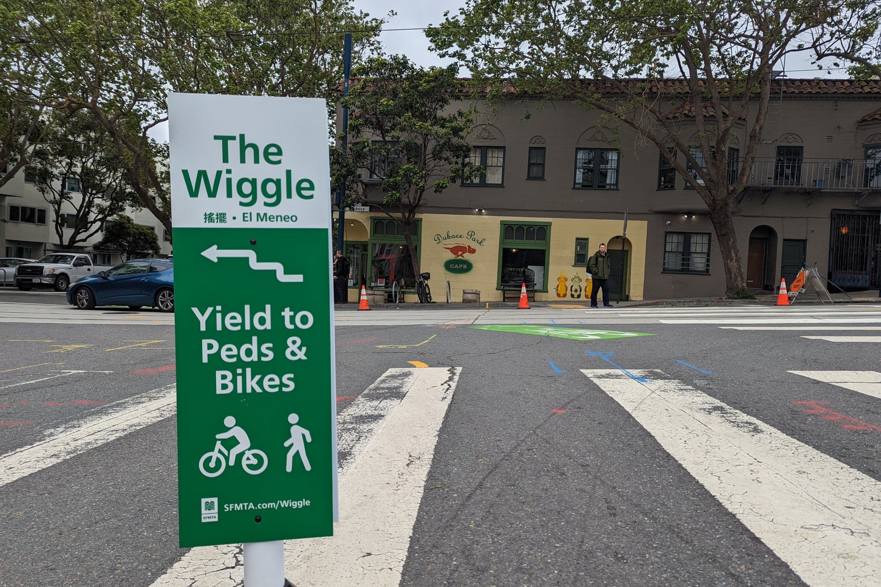
Independent Safety Advocates Beef up the Wiggle
Signs and soft-hit posts installed by advocates make the Wiggle bike route calmer and safer for cyclists and pedestrians