Walking through the Sand
I’ll be slowly going through San Francisco transit history over the next few months. All of this information is derived from our Shaping San Francisco collection that you can explore on Foundsf.org. Also, I'll be conducting a 4-hour "Transit history" bike tour on Sat. April 24. Today we start where it all began, in the sand.
 The Portolá expedition sights the Bay in 1769.
Had you been one of those settlers at the far edges of the Spanish empire, you might have been in the caravan that slowly made its way up from Monterey in 1769, crossing the dense redwood forests along the San Mateo hills to suddenly catch a glimpse of one of the world’s great harbors. Funny to think that a site so rich in maritime history now, once surrounded by the most abundant natural supplies of seafood imaginable, was “discovered” by European settlers who were traveling extremely slowly on foot and horseback.
Sir Francis Drake had passed by the Golden Gate more than 100 years earlier, as had many other seafaring explorers, but no one noticed the entry to San Francisco Bay. It was another few years, 1776 in fact, when Spanish settlers established permanent structures in what is now San Francisco, at the Presidio, and at Mission Dolores (then at the edge of a good-sized freshwater lake fed by a year-round stream gurgling down what is now 18th Street). We’ll start to examine the water-born transportation that really shaped the early city next time. But from the beginning, less than 100 Spanish settlers founded a settlement that, thanks to enslaving the local Indians (those who survived smallpox, chicken pox, and other European diseases), was able to start producing hides and tallow and carry on a modest trade with passing ships from other European powers (Russia, England, Prussia, France, and of course the USA).
They lived in two settlements, and to go from one to the other was mostly done on foot or by horseback. Early in San Francisco’s pre-history, a path was beaten that still exists today: Lover’s Lane in the Presidio, presumably so named because lonely soldiers had to walk it to the Mission to court the few eligible young women in the area. Here’s a photo that shows it from the 1870s:
 Lover's Lane has been there since the 1780s but here it is in the 1870s as seen from the Presidio gate.
Few of today’s San Franciscans know the early history of “Yerba Buena.” Most of us have a vague idea that today’s financial district was once the shoreline and that the city grew up in a hurry thanks to the Gold Rush and all the ships and people that “rushed in” during 1848-49. Curious to find out that the very first structure in what became the city of San Francisco was Captain William Richardson’s house, which he called “Casa Grande,” built on what we know now as Grant Street not far from the first landing in the city, at Clark’s Point (today’s Montgomery and Sacramento). Though the peninsula had been under Spanish rule for over 50 years, and Mexican rule for more than a decade, it was only in 1835 that a formal effort began to establish a town. Richardson built his house in 1837 after living in a tent with his wife and three children for months. (At one point he was off conducting his affairs and the family’s hearth fire went out. They waited two days until a Mexican soldier happened to walk by on the long way from the Presidio to the Mission and helped them start a new fire.) Richardson’s daughter remembered a bear reaching under the tent and grabbing one of their roosters, while his son Stephen recounted in his memoir:
One thing about the cove of Yerba Buena, or San Francisco, as it very soon came to be called, was the great number of good-sized fish that swam close in shore and were stranded by the outgoing tide. These were the natural food of all sorts of predacious animals, which existed in enormous numbers and, being little interfered with by man, for that reason were indifferent to his presence. I often used to sit on the veranda of my father’s house and watch bears, wolves and coyotes quarreling over their prey along what is now Montgomery Street.
 These dunes stretch across today's Sunset District to the sea in this 1900 shot but once upon a time they ran from the sea all the way to the Bay.
While he was watching the bears and wolves eat the sturgeon and salmon who were stuck in the tidal mud, Nob Hill climbed straight up behind his father’s house. The diagonal geologic formations of Franciscan bedrock and upthrust chert were not yet well understood, but what was plainly apparent from the beginning was the endless sea of sand that covered the peninsula, running from the Pacific Ocean nearly all the way to the Bay at Yerba Buena cove. Dunes had formed over thousands of years and much of what we now experience as the relatively flat parts of San Francisco were themselves once dominated by 100- to 200-foot-tall sand dunes, with swamps and wetlands occupying the low areas between them.
To go from their home to a small, sunny sand-dune surrounded area called Happy Valley (around today’s 1st and Mission) Richardson had to walk on a treacherous, narrow path on an extremely steep hillside. Happy Valley itself was warm and sunny with some fresh water from a natural spring, protected from the relentless wind and sand of the city by the towering 100-foot tall sand dunes to its west and north. (Early gold rush settlers set up a tent city there and within a year it was wracked with dysentery and cholera, as human waste piled up even while the sand dunes were being brought down.)
 This 1851 photo captures the now leveled sand dunes that covered the South of Market area.
In its original state, the full eight blocks south from Market to Townsend were dry land only from Second to Third. Rincon Hill had two 100-foot-high crests, near Second and Townsend, and along Harrison Street between First and Second. Hills eighty feet high stood at Second and Howard, Third and Market, and Second and Market. A salt marsh interrupted Fourth and Fifth streets near Folsom and continued northwest almost to Market. Half of today's South of Market lay under water.
 This is an artist's rendering of the northwesterly view from 9th Street and Mission Plank Road, today's 9th and Mission.
The route between the settlement at Yerba Buena cove and the old Franciscan Mission Dolores several miles to the southwest was so sandy that even a load of hay from the Mission's fields was hard to deliver into the town, and usually came by water via Mission Creek and Mission Bay. Col. Charles L. Wilson constructed a plank toll road in 1850 from Kearny Street to Third Street, and out Mission Street to Mission Dolores. It became the first reliable road across the sand and marshes. Long forgotten now is that when engineers were brought out to approve transit on the new toll road, the planks had disappeared into the marsh between 5th and 6th Streets. It took driving piles over 100 feet into the marsh to finally stabilize the wooden byway. (This city's first public transit opened in 1852 along the plank road.
The service was the Yellow Line's "omnibuses," an eighteen-passenger
variant of the stagecoach, the subject of a future post.)
Walkers and horse riders finally had a reliable way through the relentlessly shifting sands, the ubiquitous marshes, and the deep mud that would plague the city during the rainy season. The extensive redesign of the local landscape was made possible in large part by the arrival of the "steam paddy" or steam shovel. It was used, along with early rail lines that were laid down, to level the hills and dump the sand, soil, rock and debris into the wetlands, marshes, and mudflats along the shorelines.
 Here you can see the Steam Paddy at work at 8th and Harrison in front of San Francisco's first sugar refinery, in the late 1850s, a place that is now relatively flat but was then still dominated by sand ridges.
Here is a photo, taken in the mid-1860s, that captures the sprawling sand of the original landscape.
 This is the view westerly across Polk Gulch in the 1860s, but the original terrain is still largely intact.
After this vision of a bleak, sand-swept landscape, it's only appropriate that we remember too the profusion of wild flowers that also have been endemic to this landscape, especially now at the end of our rainy season. Go out and walk among our hilltops and remaining open spaces for a thrilling botanical experience. Such delight was familiar to our 19th and early 20th century predecessors too.
One of our most valuable accounts of the original landscape of San Francisco was provided by a German botanist and doctor who arrived in 1850, Hans Herman Behr. He spent time 40 years later in the 1890s writing his account of what he witnessed during those early tumultuous years, when he walked across the peninsula's dunes and took copious notes on what he discovered. Here he describes the dense botanical riches around 7th and Harrison, where Russ Gardens was established in the 1850s:
Near the formerly well-known Russ Gardens there were extensive marshesabounding especially about their borders in interesting plants. Heregrew the large-flowered Cornus nuttallii (dogwood), the Menyanthes trifoliata (buckbean), Epipactis gigantea (stream orchid),the delightfully fragrant white-flowered Habenaria leucostachys(=Platanthera leucostachys, bog-orchid), and Eriophorumgracile (cotton grass). In the same vicinity I found in a singlelocality five specimens of Botrychium ternatum (=B. multifidum, leather grape-fern); and the Asplenium filix-femina (=Athyrium filix-femina var. cyclosorum, lady-fern), grew luxuriantly,often forming rootstocks two feet high, simulating tree ferns.
Another account from 1902 describes the stunning fields of wildflowers that filled the open lands stretching from the edge of urbanization to Lake Merced and beyond. Lillian E. Purdy wrote about walking through wildflower gardens at the city's edge:
The road into this natural garden of San Francisco, where nearlyevery species of our flora grows in reckless profusion, is found bytaking the San Mateo [street]cars, which carry you out through Sunnyside and onthe border of the valley of vegetable gardens. Finally, at Ocean View,you leave the cars behind you and, walking southward along the railroadtrack for about half a mile, you cut across the field toward the ocean.From this point a most picturesque view spreads out before you. In theforeground are variegated field patches of gold, blue, rich, deep redand cream blended almost into rainbow effect—and beyond thegreen-carpeted hills, Lake Merced and a bit of ocean.
When you have crossed into the very midst of this sea of flowersyou find yourself surrounded by eschscholtzias (Eschscholziacalifornica), buttercups, wild pansies (Viola pedunculata),wild wallflowers (Erysimum franciscanum), baby-blue-eyes (Nemophila menziesii), mallow (Sidalcea malvaeflora), popcorn flowers (Plagiobothrys sp.) and numerous other varieties of California flora. The grass is fine, clean and beautiful, and, throwing yourself down to rest andenjoy, you feel that you are now in reality near to nature's heart. Allthese beautiful living things throb with life, glow with color andexhale their fragrance to the breeze. It is an exhilaration and adelight.
 Native California flora on the dunes at North Baker Beach.
 Wildflowers on Twin Peaks hint at what's been lost in the pellmell urbanization of the peninsula, but also highlight the great efforts of locals to retain and extend remnant native habitat.
Next month, the sailing ships that brought people to the new city.
Stay in touch
Sign up for our free newsletter
More from Streetsblog San Francisco
Commentary: There is Zero Ambiguity to the West Portal Tragedy
What happened in West Portal was entirely predictable and preventable. The city must now close Ulloa to through traffic and make sure it can never happen again

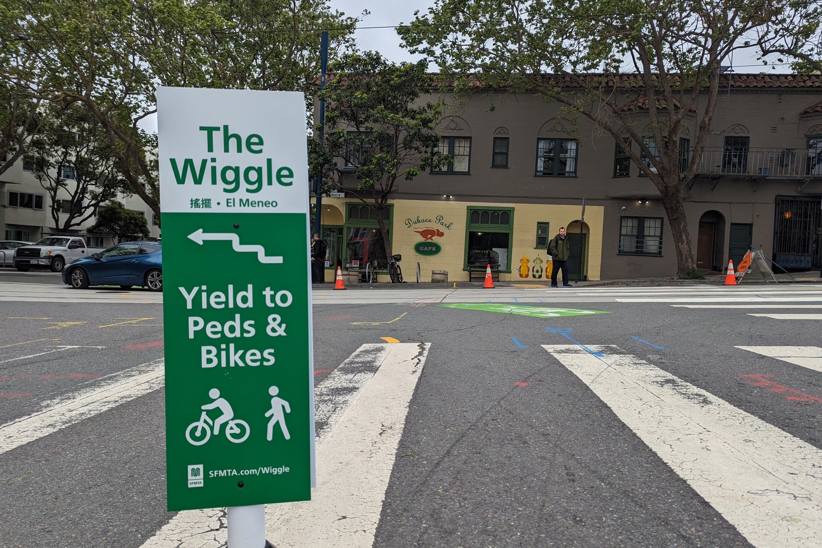
Independent Safety Advocates Beef up the Wiggle
Signs and soft-hit posts installed by advocates make the Wiggle bike route calmer and safer for cyclists and pedestrians