Caltrans Slims the Sloat Boulevard Speedway With Buffered Bike Lanes
The six-lane speedway known as Sloat Boulevard has been somewhat tamed after Caltrans implemented a road diet last week, reclaiming two vehicle lanes for bicycles.
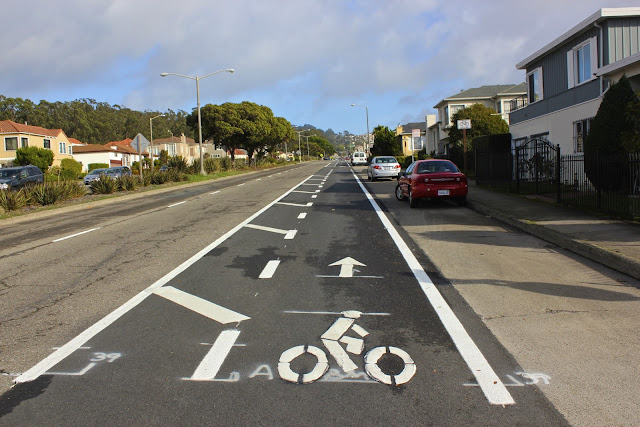
Long known as a virtual no-man’s-land for biking and walking, Sloat is technically a state highway that runs through the Parkside District. The stretch between 21st Avenue and Everglade Drive should be safer now, with new buffered (though unprotected) bike lanes running along the left side of parked cars and other pedestrian safety improvements.
“For too long, Sloat’s freeway-like design has been a danger to people who walk in the Sunset,” said Walk SF Executive Director Elizabeth Stampe. “This is a great step toward helping people feel safer and more comfortable walking around the Zoo, Lake Merced, and of course San Francisco State University.”
Mark Dreger first reported the installation on his new blog San Franciscoize (a spin-off of the famed beacon of bicycle culture, Copenhagenize):
This development is especially exciting because this portion of Sloat Blvd is a state highway (CA-35) under the jurisdiction of Caltrans. While California’s Department of Transportation does have a Complete Streets Program, they have a longstanding reputation of prioritizing movement of automobile traffic over other modes of transport. Nevertheless, the agency has gone ahead with enhancements to the safety and comfort of walking and bicycling on this important street and deserve some sincere credit.
With the roadway for cars now reduced by roughly 22 feet, drivers should feel less invited to speed. Caltrans also plans to reduce the speed limit in the near future from of 40 mph to 35 mph. Even by Caltrans’ automobile-centric standards, Dreger noted, “there is not nearly enough volume to justify three lanes in each direction.”

The bike lanes are seven feet wide with four-foot buffers (seemingly plenty of room for protected bike lanes if such designs had the Caltrans stamp of approval). The improvements on Sloat also come with visible ladder-style crosswalks, painted “yield” arrows (often called “shark’s teeth”), and signage instructing drivers to yield.
“These changes are a good start,” said Stampe. “To reduce speeds further, it would help to see pedestrian islands, wider sidewalks, and some vertical additions like trees or soft-hit posts to visually narrow the street and signal to drivers that they are not, in fact, on a freeway.”
Historically, Caltrans has acted slowly to improve Sloat, particularly at the intersection of 19th Avenue — another Caltrans highway — which is commonly ranked among the most dangerous in the city. Last year, the intersection saw three vehicle crashes in which four people were injured, according to police data. Along Sloat, two pedestrians were hit by drivers last year, and in January of 2010, 54-year-old Feng Lian Zhu was killed by a driver near Forest View Drive.
The project was initiated by Caltrans after District 4 Supervisor Carmen Chu requested safety improvements on Sloat, which divides the Parkside neighborhood from Stern Grove and the Sunset District to the north.
“Congratulations to both Supervisor Chu and Caltrans for proactively reimagining a dangerous street in to one that makes walking and biking much safer and attractive, helping many more families from the neighborhood and far beyond enjoy the many wonderful destinations in this part of town,” said Kit Hodge, deputy director of the San Francisco Bicycle Coalition (SFBC).
While bike lanes were also striped recently on nearby Portola Drive by the SFMTA as part of the SF Bike Plan, the newest ones on Sloat fall just short of connecting with those and others planned between the Great Highway and Skyline Boulevard [PDF].
No plans to connect the gaps are known as of yet, but the SFBC is encouraging supporters to let Caltrans staff and city leaders know they appreciate complete streets improvements and that more are needed.


Read More:
Streetsblog has migrated to a new comment system. New commenters can register directly in the comments section of any article. Returning commenters: your previous comments and display name have been preserved, but you'll need to reclaim your account by clicking "Forgot your password?" on the sign-in form, entering your email, and following the verification link to set a new password — this is required because passwords could not be carried over during the migration. For questions, contact tips@streetsblog.org.