Wayfinding Signs: A Nice Touch for the Developing “Green Connections” Plan
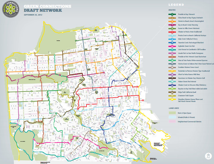
City planners continue developing a vision for a network of lush, pleasant streets prioritized for walking and biking between the city’s parks and waterfronts. Staff from the SF Planning Department plans to present its draft network [PDF] for the “Green Connections” project at an open house next Wednesday, October 3, and the public is invited to weigh in on the selected routes.
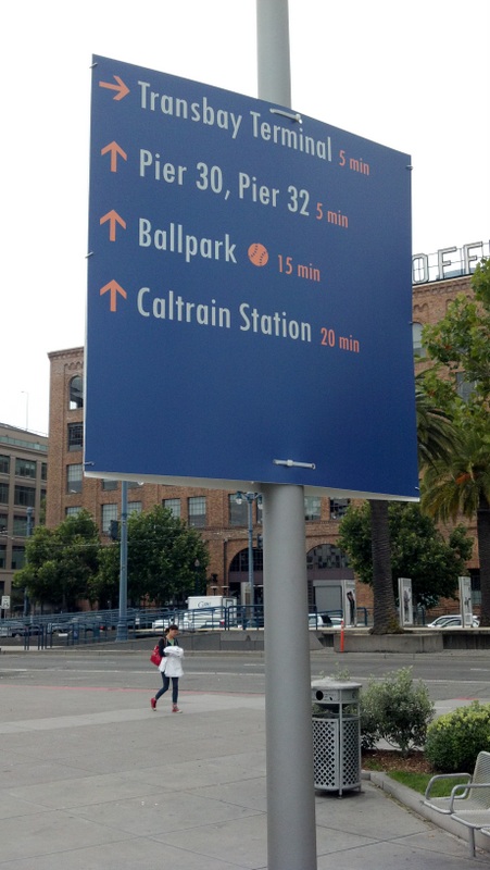
Coincidentally, one tool that could be used in Green Connections was recently implemented, at least temporarily, downtown and along the Embarcadero: Wayfinding signs listing estimated walking times to major destinations. Walk SF Executive Director Elizabeth Stampe said they’re an important way to help encourage walking, since many visitors (and residents) may be surprised to learn how quickly they can hoof it from one neighborhood to another.
“A lot of people might take the bus to North Beach, but they don’t know that they could get there in 15 or 20 minutes from downtown,” said Stampe. “Showing how easy it is to get from one place to another will help get more people walking.”
The idea of Green Connections is to lay out a plan of street routes connecting parks and waterfront destinations to prioritize for greenery, pedestrian and bicycle improvements over the next 20 years. In addition to the Planning Department’s community meetings, Walk SF has been leading park-to-park walks along with Nature in the City, and the SF Parks Alliance over the year to field residents’ thoughts on how the corridors can be improved.
The signs at the Embarcadero were put in by the SF Municipal Transportation Agency to help point visitors to, from, and along the waterfront during the America’s Cup yacht races this year and next summer. They were recommended in the People Plan, which is aimed at making it easier for visitors to walk, bike and take transit to the crowded events.
“It’s really powerful to put the distance in times rather than miles. I think it just makes it much more manageable to envision and plan for,” said Stampe. “You could wait five minutes for the bus, or you could take 15 minutes and walk and really enjoy yourself.”
Not only would the signs be useful along Green Connections routes in other parts of the city, said Stampe, but they could also be complemented with informational signs about the local vegetation and wildlife on streets near parks to add an educational touch to the stroll.
After Wednesday’s open house meeting, planners will refine the map and choose six priority neighborhood corridors for which to create conceptual street designs. Planning staffers say the plan, which is scheduled to be finished in about a year, would be used to help inform future street improvement projects, with the goal of revamping all 25 proposed routes, totaling over 140 miles, within two decades.
Living in San Francisco, “It’s easy to forget that we’re on the water,” said Stampe. “If you live and work in an area that’s not close to the bay or the ocean, you may never get there. This is a way to help encourage people to enjoy some of the great beauties of our city.”
Here’s a list from the SFMTA of all 14 wayfinding sign locations:
1. Civic Center BART
2. Grove/Larkin
3. 25th and 36th
4. Embarcadero BART
5. Market and Spear
6. Caltrain Depot
7. Ferry Building
8. Marina Green
9. Fort Mason and Van Ness/North Point
10. Townsend and Embarcadero
11. Market and Ferry
12. Embarcadero and Green
13. Embarcadero and Bay
14. Bay and Fillmore
The Green Connections Open House will be held on Wednesday, October 3, from 5:30 p.m. to 7:30 p.m. in the Rainbow Room of the LGBT Community Center at 1800 Market Street.

Read More:
Streetsblog has migrated to a new comment system. New commenters can register directly in the comments section of any article. Returning commenters: your previous comments and display name have been preserved, but you'll need to reclaim your account by clicking "Forgot your password?" on the sign-in form, entering your email, and following the verification link to set a new password — this is required because passwords could not be carried over during the migration. For questions, contact tips@streetsblog.org.