Great Highway Re-Paving to Come With Minor Bike-Ped Upgrades

The Great Highway, the motorway that divides Ocean Beach from the Outer Sunset and Richmond, is set to get some bike lane and pedestrian improvements north of Lincoln Way as part of a nine-month re-paving project started this week by the Department of Public Works.
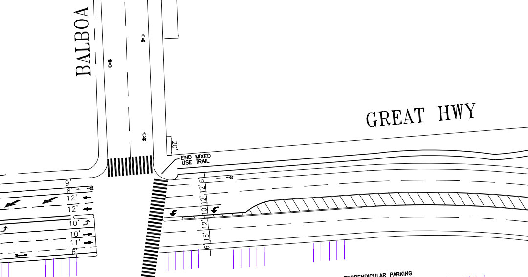
The 6-foot painted bike lanes planned between Lincoln and Cabrillo Street would be an addition to the original SF Bike Plan [PDF], which only called for bike lanes north of Cabrillo and along the length of Point Lobos Avenue. Last Friday, the SF Municipal Transportation Agency gave preliminary approval at a public hearing to extend the lanes south to Lincoln past Golden Gate Park, and the project is expected to receive final approval from the agency’s board of directors at an upcoming meeting.
While much more remains to be done to create a safer, less car-dominated Great Highway (see SPUR’s long-term vision, which includes fewer traffic lanes and a two-way, protected beach-side bikeway), the bike lanes and pedestrian refuge islands will provide some improvements in the meantime.
SF Bicycle Coalition Executive Director Leah Shahum praised the SFMTA’s adjustments to the Bike Plan, calling it “a great example of city staff working together to layer bicycling, walking, and traffic calming improvements into a repaving project, so that the benefits are tripled.”
“If this project is approved by the SFMTA Board of Directors, we will have a much more ‘complete street’ along this section of the now-intimidating Great Highway, and all road users will benefit,” she said.
The road space for the bike lanes will be created by narrowing the Great Highway’s four traffic lanes. Point Lobos Avenue, which runs by the Cliff House, will go on a road diet under the Bike Plan, with two of its four traffic lanes replaced with median space and a buffered bike lane in the northbound direction. The southbound, downhill traffic lane is only slated to receive sharrows.
Currently, the Great Highway does have a shared bike and pedestrian path on its east side, which runs from Sloat Boulevard (on the south end of the Sunset District) to Fulton on the north end of Golden Gate Park. However, the path is narrow and frequently crowded, and there is no bike lane option north of Fulton.
The bike lanes are part of DPW’s $7.3 million project to re-pave all of the Great Highway and implement the first DPW streetscape improvements to be funded by Prop B bond funds, according to the agency’s website.
Between Lincoln and Fulton at the edge of Golden Gate Park, DPW says it will add a landscaped median and pedestrian refuges, as well as ADA-compliant curb ramps at intersections.
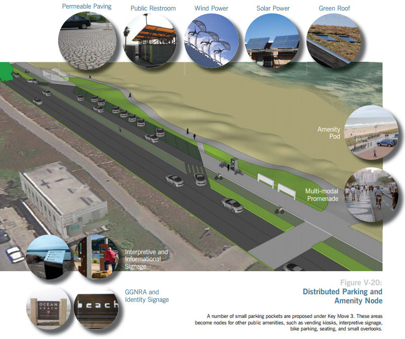
DPW says the streetscape improvements came out of SPUR’s Ocean Beach Master Plan, a long-range vision which calls for many more changes, including the eventual removal of two traffic lanes on the Great Highway south of Lincoln and the creation of a protected bikeway. The road diet would make the crossing more welcoming for people walking and biking to the beach, and prepare the highway for anticipated damage from erosion on the road’s southern stretch in the years ahead.
In a post on the SPUR blog last July, Ocean Beach Project Manager Ben Grant explained that DPW Director Mohammed Nuru proposed including the landscaped median in the re-paving project as a short-term measure, inspired by the SPUR plan.
“The project will install landscaped medians where today they exist only in paint,” wrote Grant. “It will improve pedestrian safety and access to the beach by providing shorter crossings and pedestrian refuges, as well as clarifying rights of way on large swaths of currently unmarked pavement. It will also improve the aesthetics of the highway, as well as its environmental performance, by providing much-needed greenery and increasing permeable surfaces for stormwater infiltration in what is now a large, undifferentiated slab of asphalt.”
DPW expects the project to be completed by October.

Read More:
Streetsblog has migrated to a new comment system. New commenters can register directly in the comments section of any article. Returning commenters: your previous comments and display name have been preserved, but you'll need to reclaim your account by clicking "Forgot your password?" on the sign-in form, entering your email, and following the verification link to set a new password — this is required because passwords could not be carried over during the migration. For questions, contact tips@streetsblog.org.