San Jose Proposes Better Bikeways East and West of Downtown

On August 6 and 13, San Jose Department of Transportation officials will present plans to improve traffic safety on ten streets that its Bike Plan 2020 identifies as key links in the city’s proposed 500-mile bikeway network. The improvements include new striping for both conventional and buffered bike lanes, bike detection for traffic signals, sharrows, sidewalks and curb ramps, and the removal of some turn lanes and curbside auto parking.
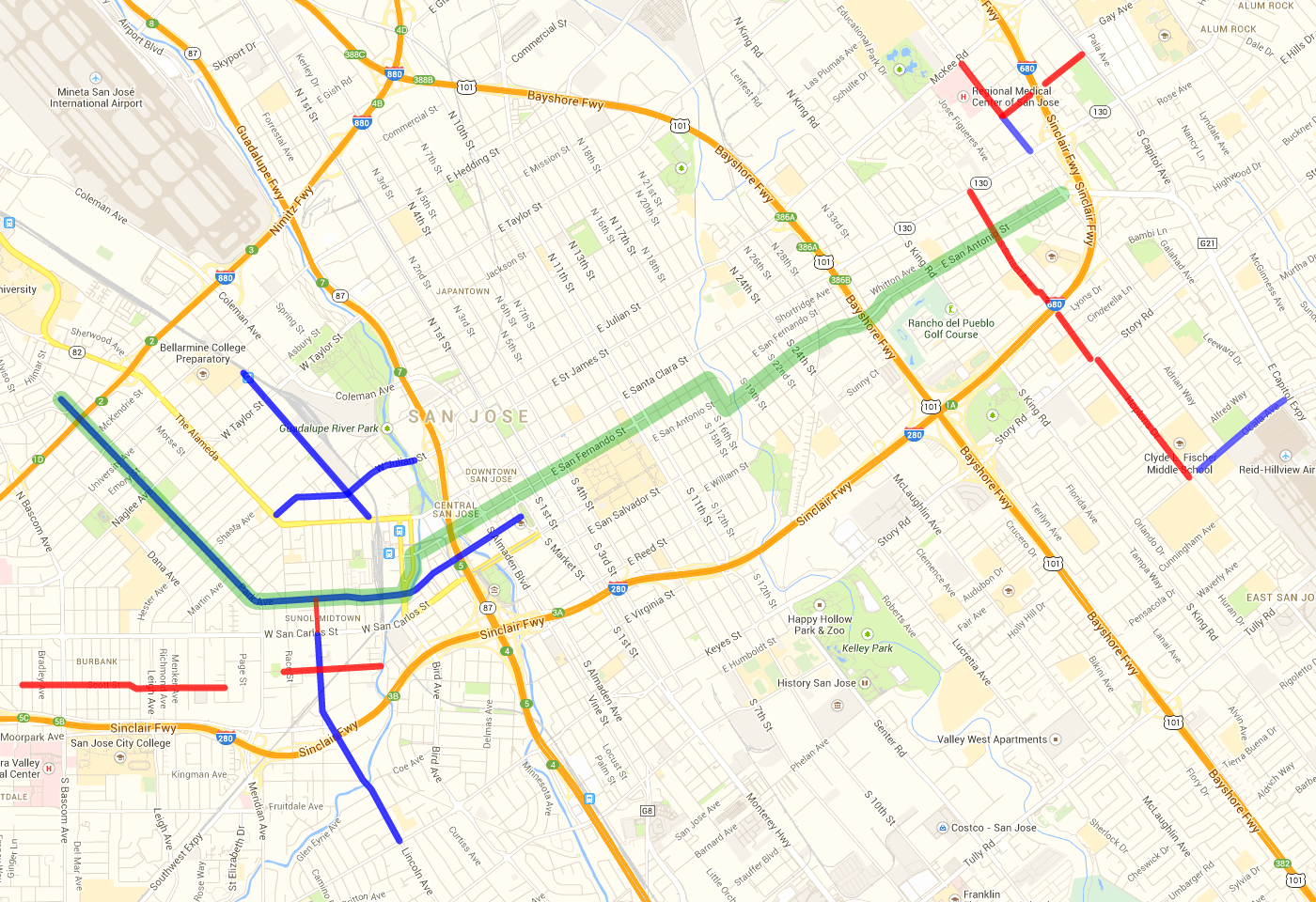
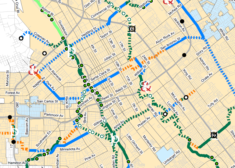
The streets included are mostly located west of and east of downtown. Several connect to the city’s critical east-west “Primary Bikeway” through downtown, which stretches from the Santa Clara/San Jose city border east, past Highway 680, to Capitol Expressway, via Park Avenue, San Fernando Street, and San Antonio Street. The city’s Primary Bikeways comprise a core network of higher-quality bike lanes and bicycle boulevards, which “serve as key cross-town facilities and support higher numbers of bicyclists of various skill levels” on streets with lower traffic volumes and speeds.
“These projects were chosen because they’re key connections,” said SJDOT Active Transportation Program Manager John Brazil. “We’re focusing our three-year work plan on central San Jose, [within] a four-mile radius from the downtown core, because trips by bike tend to be shorter trips, and are also supported by better transit in the denser urban core,” he said.
“The central parts of San Jose have the greatest densities of employment and population,” said SJDOT Deputy Director Paul Smith. “This is the area that should move first towards a greater use of bicycles.” San Jose’s Envision 2040 General Plan set a goal to gradually increase walking and bicycling trips over the next 30 years. Doing so will support several of the plan’s key community values, such as an interconnected city, healthy neighborhoods, and environmental leadership.
“Expanding San José’s comprehensive bicycle network outward from the downtown area will give more residents, workers, and customers safe and comfortable access by bike,” wrote the Silicon Valley Bicycle Coalition (SVBC) on the proposed improvements.
West of downtown, the proposed bikeway projects include Park Avenue, Lincoln Avenue, Stockton Avenue, Julian Street, Scott Street, and Auzerias Avenue.
New striping on Park Avenue would add new bike lanes where none exist, and replace existing door-zone bike lanes with a combination of conventional and buffered bike lanes. Doing so would require removing 168 parallel parking spaces between Newhall and Market streets, or the entire 2.8-mile length of Park Avenue located within San Jose. According to the city’s parking studies, 1,186 public parking spaces are currently available along or within 200 feet of Park Avenue, and maximum parking demand ranges from 35 to 85 percent.
Lincoln Avenue would also see some parallel parking spaces removed: 50 out of the 381 spaces near the intersection with Auzerais Avenue, and from Glen Eyrie Avenue to Willow Street. Standard bike lanes will then be installed, without removing any of the four travel lanes on the 1.1 mile stretch from San Carlos Street to Willow Street. That would provide continuous bike lanes from the Willow Glen neighborhood to downtown San Jose.
A total of two miles of new bike lanes on Stockton Avenue and Julian Street will connect to the Guadalupe River Trail just west of Highway 87, completing a continuous bike route from Bellarmine College Preparatory and areas east and north of The Alameda to downtown San Jose. About 1.5 miles of sharrows on Scott Street and Auzerais Avenue will create a (nearly) continuous bike route from Santa Clara Valley Medical Center and San Jose City College, at Bascom Avenue, to downtown San Jose.
The San Jose City Council has previously overruled a proposal by SJDOT to replace parallel parked vehicles with continuous buffered bike lanes on Hedding Street. It was, like Park Avenue, intended to serve as an east-west Primary Bikeway. Council members Sam Liccardo, Rose Herrera, and Xavier Campos wrote in their amendment to SJDOT’s street design that “retrofitting a 1950’s-era streetscape for more multimodal use isn’t easy,” because “residents with homes facing Hedding Street have strongly objected to the removal of street parking fronting their homes.” That seniors and parents with children would need to walk from side streets, and not have their automobiles within eyesight of their homes, were cited as reasons to retain parallel parking on Hedding Street. Thus, the street will instead have several blocks of door-zone bike lanes installed. SVBC supported the proposal, but pointed out that “retaining on-street parking was not ideal.”
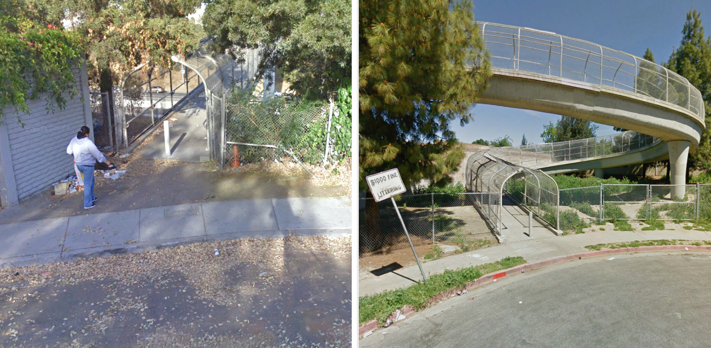
East of downtown, bikeway projects will include Jackson Avenue, Madden Avenue, Sunset Avenue/Hopkins Drive, and Ocala Avenue, and are generally less extensive than the west of downtown projects. New bike lanes and sharrows are also proposed on streets that connect to the eastern end of the Park-San Fernando-San Antonio Primary Bikeway, which will connect neighborhoods east of Highway 680 with downtown San Jose. Instead of bike lanes, these routes will consist primarily of sharrows on residential streets that have narrow pedestrian bridges crossing the highway, like at Madden Avenue and Sunset Avenue.
The 1/2-mile long Madden Avenue bikeway will be marked with sharrows, from Capitol Avenue’s existing bike lanes and over Highway 680 to Jackson Avenue. There, a 1/2-mile gap between bike lanes on Jackson Avenue between Madden Avenue and San Antonio Street will be filled, creating a continuous bikeway to San Antonio. On Sunset and Hopkins, 1.5 miles of sharrows will be painted, from Ocala Avenue’s existing bike lanes and over Highway 680 to San Antonio Street. Ocala Avenue’s existing bike lanes will be upgraded to buffered bike lanes for 1/2 mile between Daytona Drive and Capitol Expressway. A new traffic signal at Adrian Way, and raised median refuge islands, are also planned for this section of Ocala Avenue.
Unfortunately, the pedestrian bridges crossing the highway at Madden Avenue and Sunset Avenue are narrow, steep, and include vertical curbs and bollards, all of which present a variety of hazards to bicyclists. Also, Jackson Avenue will remain five lanes wide, with narrow bike lanes on its edges, and San Antonio Street — the designated Primary Bikeway connecting east San Jose to downtown — will have only sharrows rather than bike lanes, due to the high demand for residential on-street auto parking west of Highway 101.
The proposed bikeway projects will be presented by SJDOT officials at two upcoming community meetings: the East San Jose (Jackson Avenue, Madden Avenue, Sunset/Hopkins, and Ocala Avenue) improvements at Mayfair Community Center, 2039 Kammerer Avenue, on Wednesday, August 6; and the West San Jose improvements (Park, Lincoln, Stockton, Julian, Scott, and Auzerais) at Gardner Community Center, 520 West Virginia Street, on August 13. Both meetings will begin at 6:00 pm.

Read More:
Streetsblog has migrated to a new comment system. New commenters can register directly in the comments section of any article. Returning commenters: your previous comments and display name have been preserved, but you'll need to reclaim your account by clicking "Forgot your password?" on the sign-in form, entering your email, and following the verification link to set a new password — this is required because passwords could not be carried over during the migration. For questions, contact tips@streetsblog.org.