Austin Is Starting a Three-Year Plan to Fight Congestion With Bikes
Central Austin seems to have everything: a massive research university, the world’s biggest annual media festival and one of the country’s strongest local job-creation engines.
But when a city sees so much success, it runs short of something else: space.
Austin is filling up. Its freeways and arterials are packed with cars.
“Even globally, no city has solved their transportation challenges by the car alone, and Austin is no different,” says Laura Dierenfield, the city’s active transportation manager.
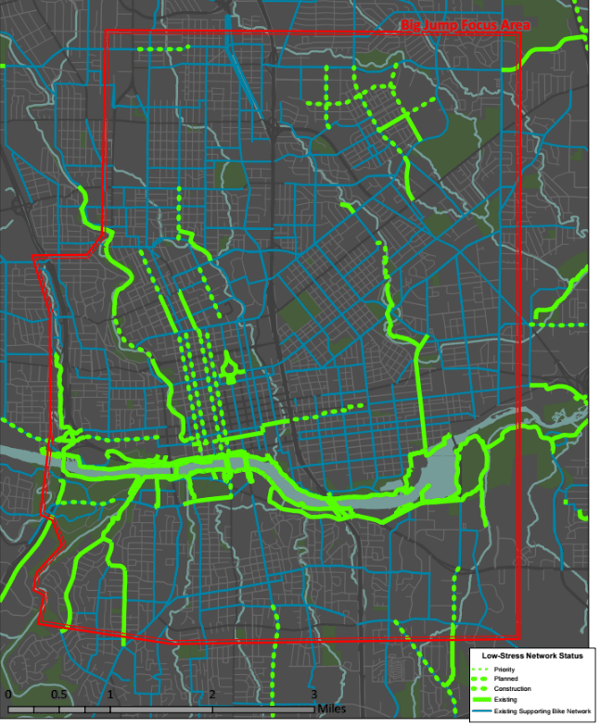
So for years, the Texas capital city has been working on a solution: street by street, major repaving projects have striped bike lanes alongside each curb. On a map, that’s given the city’s biking network the appearance of so many pick-up sticks:

But from the street, it’s clear that many of those bike lanes are hardly appealing to riders of all ages.

In the 25-square-mile area surrounding the city center, the city estimates, only about one in 20 working residents currently commutes by bike.
In the next three years, Austin is setting out to double that rate, putting thousands more bikes on its central streets each day. Their plan: to simultaneously close the gaps in the city’s biking network and to add simple physical barriers — Austin has been working for years to develop one — to more clearly separate bike and car traffic.
“There’s a fair amount of really good routes that aren’t very cohesive in the area,” said transportation planner and street designer Nathan Wilkes. “The strategy for us is: How can we super-quickly mend that together into a network?”
Last year, the city bought two narrow Tennant Sentinel bike-lane sweepers to regularly clear debris from protected bike lanes. And in November, voters gave the city a huge influx of cash: a $720 million bond measure that included $70 million for bike-related projects.
The ultimate goal: convert 7 percent of central-city trips from car to bike, adding as much new capacity to the city’s road system as a freeway expansion while also reducing transportation costs for thousands of lower-income households.
The project schedule isn’t worked out yet, and neither is any particular street’s design. But armed with everything it needs for change, Austin is about to go to work improving biking in its central city in a way it never has before. If it’s successful, the whole metro area will benefit.
“It’s not about what we can do for bicycling, but about what bicycling can do for us,” Dierenfield said. “The more trips we can convert to bicycling, the more reliable the entire transportation system becomes for everyone.”

This is the second in a series of profiles of the 10 focus areas in the PeopleForBikes Big Jump Project — districts that are planning to quickly install some of the country’s first fully connected all-ages biking networks over the next three years.
PlacesForBikes is a PeopleForBikes program to help U.S. communities build better biking, faster. You can follow them on Twitter or Facebook or sign up for their weekly news digest about building all-ages biking networks.

Read More:
Streetsblog has migrated to a new comment system. New commenters can register directly in the comments section of any article. Returning commenters: your previous comments and display name have been preserved, but you'll need to reclaim your account by clicking "Forgot your password?" on the sign-in form, entering your email, and following the verification link to set a new password — this is required because passwords could not be carried over during the migration. For questions, contact tips@streetsblog.org.