Seamless Bay Area Solidifies Vision for Regional Transit
Note: GJEL Accident Attorneys regularly sponsors coverage on Streetsblog San Francisco and Streetsblog California. Unless noted in the story, GJEL Accident Attorneys is not consulted for the content or editorial direction of the sponsored content.
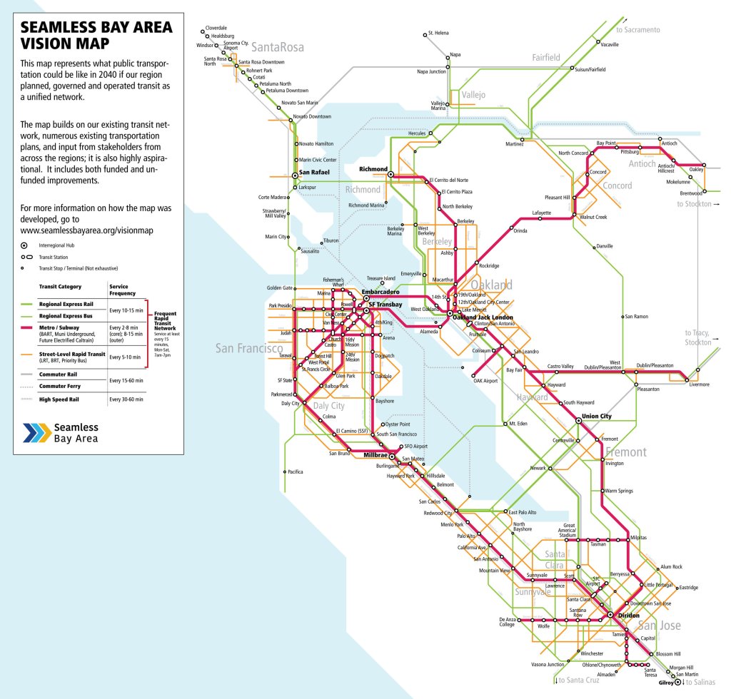
Seamless Bay Area, a group that advocates for integrated fares and coordinated transit schedules, has released the next step in its vision for a more transit-friendly region: a map of the Bay Area megaregion’s transit future. The map, seen above, is a key component that was developed in partnership with Interline, and funded by a grant from Microsoft. “Seamless Bay Area’s goal in modeling this future system was to determine how to make it faster and easier to get around the Bay Area, and to uncover the associated benefits,” writes the group.
Now, before the naysayers chime in, this isn’t just another fantasy map.
Seamless is putting together a vision, based on European models, for lawmakers to reference in preparing for a future mega-measure to fund transit. And one of the contingencies for that funding, is–or better be–that transit operators will be required to participate in a rational, transparent fare system that eliminates transfers and requires fare operators to coordinate schedules into a hub/pulse system. That, say most advocates, is the only thing that’s going to get them to look beyond their parochial goals.
“The problem isn’t that there are 27 agencies, it’s that there’s no clear regional framework,” said Ian Griffiths, co-founder of Seamless, during a SPUR talk Tuesday afternoon in San Jose on transit modeling. “This is particularly urgent given the rapid tech changes that are happening, with autonomous vehicles for example. This could make it much more difficult to prioritize transit in the future.”
Griffiths illustrated everything that’s wrong with transit in the Bay Area with his own experience just getting to the SPUR meeting. He tweeted about his missed connection between BART and Caltrain at Millbrae, which forced him to take Lyft (which fortunately, he says, he has the means to do):
If the Caltrain conductor had bothered to think about the BART passengers needing to make a connection, he would only have had to hold the doors for another few seconds. Instead, the train took off–leaving everyone to wait an hour for the next train or find some other means of reaching their destination.
The Lyft ride would have been expensive, but the BART-to-Caltrain transfer is already expensive anyway, because there is no fare integration between the two agencies.
If that problem isn’t solved, building new transit lines would just be putting the cart before the horse. Drew Dara-Abrams of Interline, Seamless’s partner in this effort, explained that transit has to be looked at in terms of opportunities and travel time throughout the entire region, to maximize its potential. In other words, it has to be seen as an integrated regional system–which means we have to move away from the simple, isolated ridership projections often used by agencies trying to sell a new transit line.
To do this, Interline uses technology similar to the old 1990s “MapQuest” Internet mapping service, which gave step-by-step directions between two points (its underlying algorithms, said Dara-Abrams, are what powers most mapping software today). Applying this technology to transit planning, he said, results in isochrone maps, which show distance plus time–and can show how a new transit line allows more people to reach more jobs and housing in a short amount of time, throughout a transit network.
These “maps show bands, visualizing one point to many points,” explained Dara-Abrams. “You compute a ton of point-to-point directions, you estimate ETA, and draw out contour lines.” He showed an example of how that kind of isochrone map works by getting results for a dedicated bus lane on El Camino Real. In the map below, the blue area shows current access and the gold area represents what could be reached via BRT, all within 45 minutes of travel from a given address along the line, in this case the intersection of El Camino and Showers Drive.
“This lets you answer questions about not just where can you go, but opportunities,” he said. That means opportunities to get to jobs in a reasonable time-frame, not just along the proposed bus line, but on everything it connects with. He added that it also lets planners think differently about rail lines, which generally offer many access opportunities near stations, but little or none between stations. Planners often make the mistake of encouraging development along rail lines rather than near stations. Isochrone maps help planners see where they need to focus housing and jobs.
Unfortunately, this kind of modeling doesn’t predict ridership directly, so it isn’t used by the Feds when deciding which projects to fund. Lisa Zorn of the Metropolitan Transportation Commission was also at the SPUR discussion to talk about how planners predict ridership and reductions in vehicle miles traveled. It’s a difficult task that requires multiple assumptions. The underlying problem, however, is that without the integration that Seamless is advocating for, it’s hard to get people onto transit no matter what you build. In the end, it comes down to people making choices about how they get around. “You might have a sixty-minute transit path, but the auto path is five minutes,” said Zorn. When it takes that long to use transit, “it’s hard to convince people to use it.”
In other words, Caltrain upgrades won’t matter that much if they don’t coincide with better connections to other transit systems. An electrified Caltrain may be faster from station to station, but if it continues to strand BART customers at Millbrae because the two systems ignore each other, as happened to Griffiths, it won’t help.
Meanwhile, Ryan Park of AECOM, who also spoke at SPUR, said a plan is in the works to reduce travel times and shorten headways on all the region’s transit systems. Through electrification and other rail upgrades, the idea is to make it so one can get from Sacramento, or San Jose, to and from anywhere else in the larger region within ninety minutes. “Within this vision there would be travel time savings, and it would become even more competitive with the car, even in off-peak,” he said.
Of course, this is going to require major investments, including a potential “megabond” upwards of $100 billion for the region. But first Seamless has to get the transit agencies to start viewing themselves as part of a single network, instead of always focusing on their individual goals. Overall, “This has the potential to bring not just a thousand new riders, but hundreds of thousands or millions of new riders, which is what we need to think about if we really want to reduce the amount of driving,” added Griffiths.
For more on Seamless Bay Area’s vision, visit their page.
For more SPUR talks, visit SPUR’s events page.

Streetsblog has migrated to a new comment system. New commenters can register directly in the comments section of any article. Returning commenters: your previous comments and display name have been preserved, but you'll need to reclaim your account by clicking "Forgot your password?" on the sign-in form, entering your email, and following the verification link to set a new password — this is required because passwords could not be carried over during the migration. For questions, contact tips@streetsblog.org.