Options for an Estuary Crossing
Planners at the city of Alameda, Alameda County, and the city of Oakland are in the earliest phases of looking at design options for a pedestrian and bicycle-only crossing of the 800-foot-wide estuary that separates Jack London Square from Webster Street and the western end of Alameda Island.
Given the narrow width of the estuary, this should be a relatively simple draw-bridge project, explained Andrew Thomas, a planner with the city of Alameda, who helped lead a public discussion and presentation Tuesday evening at the Crooked City Cider Tap House in Jack London Square. The event was organized by the Jack London Improvement District. “I took a water bike across the estuary,” said Thomas. “It took 90 seconds to cross.”
Unfortunately, the Coast Guard maintains cutters farther up the estuary and has final say over the project. They have refused to post the cutters to a different location and are demanding a 600-foot horizontal clearance for the lifting part of the bridge, even though their ships are only 54 feet wide. This jacks up costs, of course, on a bridge that will already need an operator on-site, 24/7, not to mention the motors and mechanics and maintenance involved in keeping it always ready to lift.
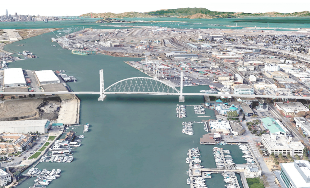
The bridge also has to be high enough even in the down position to clear nearly all sailboats, at about 70 feet, as seen in the diagram below (otherwise it would be lifted too frequently to be useful):
Initial cost estimates are about $140 million, with $113 million for the actual bridge and the rest for the approach ramps, said Thomas.
He added that a car bridge, which would be far more expensive, has been ruled out. Between the Posey and Webster tunnels and the Park, Fruitvale, and High Street bridges, there are already more car lanes between Oakland and Alameda than on the Oakland Bay Bridge. Adding more car lanes would just move bottlenecks around, without providing additional capacity.
All of these constraints have more or less dictated the design of the span. Choices come down to the shape of the ramps and where exactly the crossing should be placed. As seen in the diagram below, there are options that link to the Lake Merritt BART station (just north of the landing points of D1 and D2), options that take the bridge closer to downtown Oakland, and the ‘F’ option which lands in between. Each of these considers various corkscrew or switchback style ramps on the approaches.
Some in the audience, which consisted of advocates from Bike East Bay and Walk Bike Alameda as well as other interested observers, favored the idea of landing near Lake Merritt BART, which would be helpful to commuters heading south towards Hayward and Fremont. That option also offers better proximity to the new housing developments at Brooklyn Basin. Others preferred more direct access to downtown Oakland. The Washington Street option also offers a possible direct connection to the new ballpark (if approved) and the gondola proposed by the Oakland A’s.
Rochelle Wheeler of the city of Alameda stressed that the ramp and landing choices are very preliminary and aren’t meant to imply that these are the only possibilities.
Meanwhile, David Koo, an urban & landscape designer with Groundworks, showed inspirational pictures of bike and pedestrian bridges from around the world.
Here are just a few:
The group will be doing more outreach–and setting up a web page for additional comments.
The bridge will take years to get funded, designed, and constructed. In the shorter term, Thomas said developers in Oakland and Alameda are coming together with plans to run a water shuttle in the next few years (which would take bicycles). Streetsblog will be checking back on that project too.
Please post pictures for bicycle bridges that inspire you. And post any thoughts you have about the proposal. At this early phase, readers can no doubt contribute ideas that will influence the final design.

Streetsblog has migrated to a new comment system. New commenters can register directly in the comments section of any article. Returning commenters: your previous comments and display name have been preserved, but you'll need to reclaim your account by clicking "Forgot your password?" on the sign-in form, entering your email, and following the verification link to set a new password — this is required because passwords could not be carried over during the migration. For questions, contact tips@streetsblog.org.