In this year’s installment of its annual Highway Boondoggles report, U.S. PIRG Education Fund and Frontier Group warn of billions of dollars in proposed spending on unnecessary highway projects that would divide our communities, deprive transit of scarce funds, and pollute our air and water. Below is the second of seven installments detailing these harmful projects.

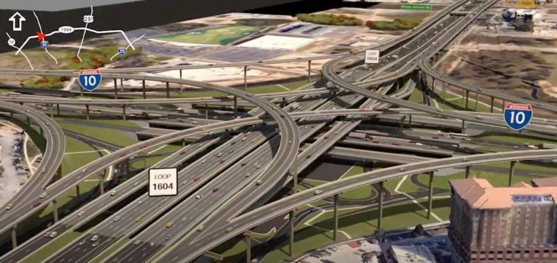
The Texas Department of Transportation (TxDOT) is currently reviewing plans for a major expansion to a 23-mile section of Loop 1604, a suburban highway loop that encircles San Antonio. The project, which would expand Loop 1604 between state Highway 16 and Interstate 35 north of the city, includes four to six additional lanes along the entire length of roadway, new frontage roads and a five-level interchange with Interstate 10. This $1.36 billion expansion, while likely failing to solve local congestion problems, would threaten one of the region’s primary sources of drinking water.
Expanding Loop 1604 is unlikely to alleviate congestion, the project’s stated primary purpose. As a 2019 San Antonio Express-News article noted, “scores of urban planners have lamented similar suburban highway loops in Houston, Austin and Dallas” as “no amount of widening Loop 1604 could keep up with the explosive growth of vehicle traffic.” San Antonio can look to a recent local example of the phenomenon of induced travel, in which additional capacity causes more driving and congestion. Despite a project to widen the northern section of Loop 410, which was completed in 2010, that section of the loop is still among the most congested highways in Texas.
Even as the Loop 1604 project will likely fail to achieve its transportation goals, it will pose a pollution threat to the Edwards Aquifer, an important source of drinking water for the region. The Edwards Aquifer is an underground body of fresh water stored in interconnected caves and porous limestone that serves as the primary water source for residents of San Antonio and much of the surrounding area. The Loop 1604 expansion would add 198 acres of impervious surface to the aquifer’s recharge zone, which is the primary area in which rainfall and streams enter and refill the aquifer.
The risks of developing the recharge zone have been known for decades. For example, a 1999 study found that “increasing residential and commercial development on the recharge zone increases the potential for runoff containing toxic substances, oil spills, or leakage of hazardous materials to contaminate the regional drinking water supply.” In 2010, the organization Aquifer Guardians in Urban Areas filed a motion to block an interchange project in this section of Loop 1604 on the grounds that it threatened the aquifer. One affidavit supporting the motion noted that past research found the aquifer suffered from pollution similar to that originating from “roadway construction, operation, or indirect effects”, and that the aquifer “is most susceptible to contamination by pollutants that originate on the Edwards Aquifer Recharge Zone, where the proposed roadway project would be sited.” The project’s Draft Environmental Assessment, released in August 2020, also notes that during construction the project “may indirectly affect underlying groundwater quality … through the erosion of disturbed soils and spills of construction related materials,” and that during regular use “the additional impervious cover would accumulate pollutants which may infiltrate to the underlying groundwater if the runoff is not treated.”


