Richmond-San Rafael Bridge Path Threatened Again
Note: GJEL Accident Attorneys regularly sponsors coverage on Streetsblog San Francisco and Streetsblog California. Unless noted in the story, GJEL Accident Attorneys is not consulted for the content or editorial direction of the sponsored content.
If you drive a car, your time is worth six or more times more than if you ride a bike (or an e-bike). That’s the unspoken premise of a new study from the Transportation Authority of Marin, indicating that opening the third lane on the upper deck of the Richmond-San Rafael Bridge to motorists means “northbound US 101 would have a peak hour time savings of 11 minutes” by 2025. Southbound motorists, meanwhile, “would have an increased [emphasis added] peak hour delay of 3 minutes.”
But as the Marin County Bicycle Coalition’s Warren Wells points out, opening the lane to motor vehicles means forcing cyclists to take a bus to get across the bridge. “No attempt is made to account for additional time costs to the admittedly smaller number of bicycle commuters, of which I am one–saving 11 minutes for a motorist costs a bike rider hours.”
Clearly, TAM officials still think “transportation” only means cars, because nowhere does their study mention how much longer commutes would become for cyclists. Wells, along with advocates from aligned organizations, point out the study’s failings in a joint letter to the TAM Board of Commissioners:
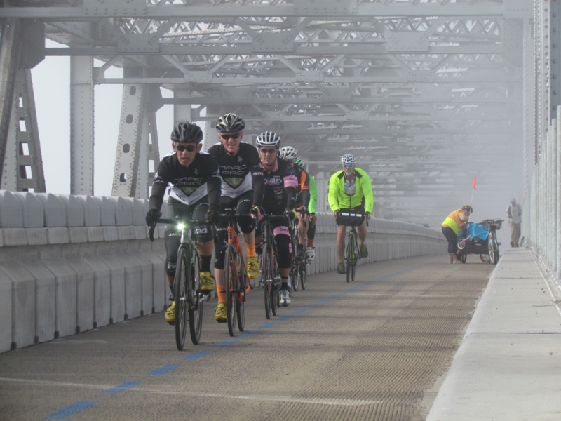
At the September 23rd, 2021 meeting, the TAM Commissioners will review the findings from a recent study to evaluate the costs and benefits of replacing the current multi-use pathway on the top deck of the Richmond-San Rafael Bridge with a third automobile lane during commute hours. We—the Marin County Bicycle Coalition (MCBC), Bike East Bay, and Trails for Richmond Action Committee (TRAC)—feel that important costs and drawbacks of the project alternatives have been ignored. While the proposal suggests short-term benefits to reducing westbound traffic congestion, we point out that this project will result in increased greenhouse gas emissions and vehicle miles travelled at a cost of $70M-$320M while diminishing access via sustainable transportation modes, such as biking and walking. Additionally, the project removes a multi-use path that closed a 4.5-mile gap in the San Francisco Bay Trail network and complies with the McAteer-Petris Act.
Any decision involving such a crucial piece of our transportation infrastructure needs to thoroughly consider environmental impacts on neighboring communities, multimodal access, and greenhouse gas reduction.
The letter also points out the obvious omission of “induced demand,” the well-understood fact that increasing road capacity tends to increase congestion in the long run. “Decades of transportation research shows that increasing auto capacity leads to increased greenhouse gas emissions. No accounting of the costs of this project can be complete without estimates of additional emissions induced. An Environmental Impact Report would need to be prepared, in compliance with California Public Resources Act Code §21000 et seq,” point out the advocates in their letter.
That said, the ultimate layout of the bridge may be shaped more by the Marin Municipal Water District (MMWD) than TAM or Caltrans. As the TAM study points out, the Water District “has begun evaluating the feasibility of placing a 24-inch pipeline on the RSRB to bring water to Marin during the current and potential future extreme drought. Two locations on the bridge are being evaluated, one in the current multi-use path and one placed underneath the upper deck.”
If the pipe is placed on the upper deck, there won’t be enough room for cars and the bridge will remain with two motor-vehicle lanes on the upper deck. Is there room for a 24-inch pipeline and the bidirectional bike lane to co-exist? It says that “MMWD is still determining if the multi-use path can co-exist with the water pipeline” in the TAM documents. One hopes if the MMWD and Caltrans work together the multi-use path could co-exist with the pipe. If so, the water project might ultimately turn out to be the only thing that saves the path.
The study, of course, is the latest in a long line of actions, lead by confessed drunk/hit-and-run driver Marin Supervisor Damon Connolly, who sits on the governing boards of the Metropolitan Transportation Commission and TAM, to get rid of the multi-use path and turn all of the bridge back over to private cars. Those efforts began almost the moment the bike-and-ped path first opened, back in 2019.
Click here for information on how to watch and participate in the next TAM board meeting, Thursday, Sept. 23 at 6 p.m.

Streetsblog has migrated to a new comment system. New commenters can register directly in the comments section of any article. Returning commenters: your previous comments and display name have been preserved, but you'll need to reclaim your account by clicking "Forgot your password?" on the sign-in form, entering your email, and following the verification link to set a new password — this is required because passwords could not be carried over during the migration. For questions, contact tips@streetsblog.org.