Will San Leandro Get Safe Bike Lanes?
Note: GJEL Accident Attorneys regularly sponsors coverage on Streetsblog San Francisco and Streetsblog California. Unless noted in the story, GJEL Accident Attorneys is not consulted for the content or editorial direction of the sponsored content.
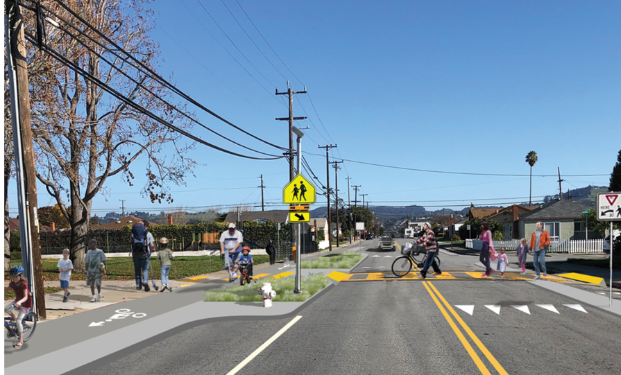
A push is on to get protected bike lanes installed in the Bay Area suburb of San Leandro. That’s why Bike East Bay, along with local advocates, lead some fifteen people on a ride down Williams Street on Saturday morning, from the BART station to the shoreline, to get people familiar with a proposed project to add either a two-way cycle track on one side of the street or protected bike lanes on both sides.
“Williams Street is one of the few streets without freeway ramps,” said Bike East Bay’s Dave Campbell, explaining to the group why this particular street is in line for improvements. Bike East Bay also plans a temporary pop-up demonstration using flex-post-protected bike lanes along a single block in the near future to give residents who may not be familiar with safe-street designs an idea of what “protected bike lane” actually means.
The Williams Street project is part of two main streets the city of San Leandro has slated for upgrades. The other is Bancroft Avenue. Fehr and Peers is the lead consultant on the project.
The six-mile, round-trip ride proceeded at a leisurely pace, with one stop at John Muir Middle School on Williams Street to attend an open house hosted by Fehr and Peers.
There is currently no bike infrastructure between BART and the shore–aside from painted lines–except for a very short cut-through just before the San Leandro Marina, seen below.
Enormous surface-level parking lots, driveways, and on-street parking–not to mention the massive amount of parking along the Marina–constitute what seemed to be the largest single use of land on the route.
The choice of John Muir Middle School for the open house was a good one, as it illustrated how many residences there are around the school and how unsafe it is for kids who might want to bike to class. In addition to the protected bike lanes, the area could certainly benefit from a raised crosswalk that uses physics (rather than just lights) to force motorists to slow down at this key juncture.
At the school, the group of cyclists was joined by local residents. “I’m thrilled about the enhancements,” said Stefanie Pruegel, who was jogging through the area. Pruegel, who is originally from Germany, said she’d favor either of the two proposed bike lane designs. “I just want to see more critical mass… anything to make biking more attractive.”
Avery Marmon, a consultant on the project, said the biggest challenge won’t be local residents, but merchants along parts of the route who might complain about loss of parking. Residents, however, “have been overwhelmingly positive and are intent on learning how we can separate cars and cyclists.”
Aside from the choice of which configuration (two-way on one side of the street, or one-way on both sides) a consultant at the open house said it has yet to be determined whether the bike lanes will be street-level or raised.
Sean Cunningham, a teacher at John Muir, thinks that “Option 2, the Directional Bikeway” is the safer choice, because of intersection hazards created by two-way cycle tracks.
That corresponds with real-world data. Two-way cycle tracks are safer than no cycle track at all, but they’re more dangerous than what’s proposed in Option 2, except in specific instances, such as along a shoreline with few to no intersections. The problem with a two-way cycle track is that motorists at intersections or driveways won’t be looking for a cyclist coming from the opposite direction of the flow of traffic (in effect, it forces cyclist to ride on the wrong side of the road).
Cunningham thinks if directional bikeways are picked, however, they should be extra wide in front of the school. He pointed out that kids riding from the residential neighborhood to the west of the school will want to ride on the same side as the school to reach its entrance, and shouldn’t be forced to cross the street twice. This is a problem now, even with the existing paint-only lanes, as the sign below illustrates. Cunningham wants the plan to work with this tendency, rather than fight it.
BART Board Director Robert Raburn was also on the ride. “Our goal is to make sure people get to and from our fare gates safely,” he said.
A little more from the project’s website:
San Leandro Crosstown Corridors Project Goals:
- Safety: Develop street designs that provide separated bikeways and improvements for walking that help people feel safer and more comfortable on Bancroft and Williams.
- School Access: Improve access for students and families walking and biking to school on Bancroft and Williams
- Multi-Modal Connections: Bancroft and Williams will support access to BART, businesses, parks, and other community destinations for all modes, prioritizing sustainable and active transportation.
Another consultant on the project noted that the two-way cycle track configuration has a significant advantage in that it would remove less parking, thereby making it less controversial with merchants who drive and with motorists generally.
However, the stated goals of the project are about safety, school access for families walking and biking, and multi-modal connections that “prioritize sustainable and active transportation.” A San Leandro High School student was struck by a driver just last September. That’s just the kind of incident that top-notch protected bike lanes and other upgrades can prevent, both by narrowing the street and giving more people an alternative to driving.
And yet the project already seems to have a proverbial thumb on the scales towards compromising safety. Note the cross-section diagram two images up already shows two red marks against option two, one of which is “more parking removal.” Nevertheless, while preserving parking might be more politically expedient, it contradicts the stated safety and sustainability goals of the project.
Streetsblog took the liberty of fixing the graphic:
Streetsblog concedes that Option 1 may indeed be better for shrubs.
Advocates can take the poll here. Bike East Bay will be holding a second ride and visit a corresponding open house next Saturday, March 19, in San Leandro for the Bancroft Avenue project. A decision on the designs should be made this summer.
Note: an earlier version of this story incorrectly stated that there were currently no protected bike lanes in San Leandro. There is a short one near Bay Fair BART.

Streetsblog has migrated to a new comment system. New commenters can register directly in the comments section of any article. Returning commenters: your previous comments and display name have been preserved, but you'll need to reclaim your account by clicking "Forgot your password?" on the sign-in form, entering your email, and following the verification link to set a new password — this is required because passwords could not be carried over during the migration. For questions, contact tips@streetsblog.org.