This article first appeared in the Frisc and is reprinted with permission.
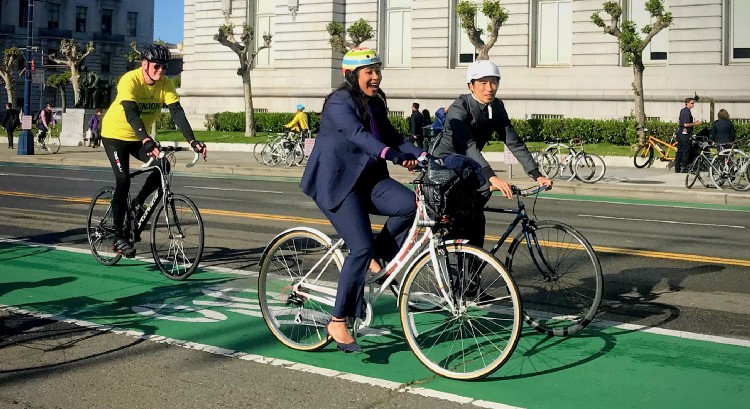
The post-pandemic future of San Francisco’s streets is at hand. Next month, the city’s transit agency board will debate the Slow Streets program, which has limited cars on more than two dozen stretches of road and invigorated a vision of a very different city that might live up to its promises of safer streets and cleaner air.
In the run-up to the October meeting, which has been pushed back more than once, an advocate coalition is crafting a template for a denser web of bike- and pedestrian-friendly streets.
It’s unclear if this plan, still a work in progress, will be welcomed by City Hall, let alone incorporated into an official version. The blueprint is a response to Mayor London Breed’s streets manifesto, posted in late July.
“We read her piece and agreed with her words,” said Jodie Medeiros, executive director of Walk SF, one of six groups drafting the plan. “Now we’re working to achieve that for the city.”
The draft calls for the city to double the Slow Streets program to 100 miles and spread them more equitably, especially in lower-income neighborhoods. The move comes after the mayor’s team raised hackles by intervening in one slow street fight.
SFMTA, the city’s transit agency, said the hearing is tentatively scheduled for Oct. 14, and agency staff will have a proposal that includes an initial list of specific streets.
The emergency Slow Streets program, created in April 2020 to give locked-down residents more space outside, seemed poised to be an SF fixture when the SFMTA board made four of them permanent in August 2021. What’s more, after months of contention, the Board of Supervisors voted in April to make the eastern end of JFK Drive in Golden Gate Park permanently car-free.
There has been backlash. Car-free JFK and the Great Highway, closed on weekends to cars, are now the target of a ballot measure this November that would reopen them to cars full time.
In the Sunset district, the city backed away from big changes and has settled for speed bumps and other traffic calming measures. A neighborhood fight also erupted over slow Lake Street, one of the first four to be made permanent. Breed’s intervention set off acrimony among advocates, as well as the full reevaluation coming next month.
“Making Lake slow and then taking actions to encourage cars makes for confusion on what’s probably one of the most effective slow streets,” said Luke Spray, associate director for SF Parks Alliance.
Amid all the tussling one street at a time, a much larger point has been obscured: San Francisco stands at the precipice of a new era. Street safety, density, climate change, a commitment to public transit, along with what’s likely to be a rearrangement of our downtown, are all core considerations in shaping the city into the future.
To date, that conversation hasn’t happened. “There’s been nothing that talks about a future vision of the city as a whole,” said former SFMTA planning director Sarah Jones, who is now assistant director of the Marin County Community Development Agency.

The third wave
San Francisco has made drastic changes before. Historically, it’s gone through two major street transformations. First, horses and horsecars gave way to cable cars, trolleys, and trains. The second came when rail service mostly capitulated to buses, and of course cars.
A third transformation is underway. One could say it began on October 17, 1989, when the Loma Prieta earthquake damaged the Central and Embarcadero Freeways beyond repair. Tearing them down allowed Hayes Valley and a new, scenic thoroughfare along the Embarcadero to blossom. But this change is far from complete, and moving ahead isn’t assured. (In Oakland and Berkeley, COVID-era car-free streets recently ran out of gas.)
Slow streets are only one piece of the puzzle. SFMTA says it has laid down hundreds of miles of bike lanes, but only 42 of them are protected from cars. There is still a major gap between what the city has and what it has promised. Fifty years ago, it was a pledge to be “transit first.” (It’s in the city charter.) More recently, the city has set goals for street safety (Vision Zero) and greenhouse gas emissions.
Sup. Gordon Mar, who represents the Sunset, wrote in a Sept. 13 tweet that Proposition I on November’s ballot was an example of “climate denialism.” The measure would reopen JFK Drive to cars and block removal of part of the Great Highway that’s threatened by rising seas.
But Mar also helped broker the August 2021 compromise to bring cars back on weekdays to the main stretch of Great Highway, which shows how our elected officials’ commitment to SF’s stated values — not to mention scientific evidence — are tempered by politics.
The evidence for slow
While opponents cite congestion, safety, and access as reasons to dismantle slow streets, a growing amount of information points in the other direction. Here’s what we know so far:
Congestion: Overall, SFMTA’s 2021 assessment showed that slow streets did not make traffic on nearby streets worse. This was also true across two studies of Lake Street, and those data were bolstered by an overlapping study of California Street, one block south, which had a lane reduction and other safety measures two years ago.
Another study of cars that could no longer use routes that cut through Golden Gate Park showed a decrease in travel time for 75 percent of those trips.
Where congestion has become a problem, the city has worked to fix traffic flow. At the western end of Golden Gate Park, the park and transit agencies altered some street closures to improve flow around Chain of Lakes Drive.
The Great Highway’s pandemic closure sent cars onto smaller streets like La Playa; SFMTA added traffic calming measures. The transit agency has already targeted intersections around Sloat, Skyline, and the Great Highway for safety and traffic flow improvements.
Safety: The SFMTA study showed that slow streets improved overall safety. Generally, most of them reduced traffic to less than 1,500 cars per day, at speeds below 20 miles per hour, which SFMTA called an “ideal range.” Collisions fell on average 36 percent. (Studies reinforce the link between speed and injury or death.)
These factors also inspired people like Martín Muñoz to get on a bike. Muñoz said he previously walked or took public transit as he was nervous about riding on city streets. “On slow streets, as a biker, I feel safer,” added Muñoz, a slow streets advocate.
Beyond slow streets, safer bike routes have also provoked years of protest. When a major bike commuter route was extended along the Panhandle, reducing Fell Street from four to three lanes, the fire department said congestion could impede emergency vehicles.
A one-year study by SFMTA and the fire department showed average travel time on that stretch of Fell increased by just 17 seconds at weekday peaks, according to Sup. Dean Preston’s office, which coordinated the study. Weekend peak averages actually dropped by 11 seconds.
Opponents can cast doubt on SFMTA studies, and that’s their right. (The Frisc has questioned some SFMTA data when warranted.) But with street improvements, there is little evidence of worsening conditions; when there is, like near Ocean Beach, SFMTA has proposed fixes.
Popularity contest
Alongside traffic studies, surveys have shown that most slow streets are popular from JFK and the Great Highway to the neighborhoods.
Even Lake Street, which drew heated opposition, got a thumbs-up. A majority of people who live on and near Lake — 83.5 percent and 53.4 percent, respectively — said keep it slow. But 46.1 percent of respondents who live on adjacent roads wanted to kill the slow roll, and that vocal minority was enough to get the mayor involved.
“This is something that’s hard to balance, but we’re going to do what’s best to slow down traffic there,” Alexandra Sweet, Mayor Breed’s transportation adviser, told The Frisc. SFMTA has already begun to make changes on Lake, allowing full car access but with low-rise speed bumps and more stop signs along the way.
The city had to reexamine all slow streets, even those the SFMTA board voted to make permanent, according to Sweet, because of a 2021 state law that codified the right to make “slow” changes. In her post this summer, Breed wrote that the program “needs work” and should evolve: “Some streets that were included in the pandemic response make sense and others do not, and other streets that were left off the table should be considered.”
Slow and equitable
Since the 1989 Loma Prieta quake, SF has made some strides toward a third urban transformation. In 2018, the Board of Supervisors changed building codes to allow new developments to forgo on-site parking, which to some extent resets what urban life could be like. Bike lanes have emerged.
On SF’s 1,200 miles of roads, some intersections now include bulb-outs and crosswalk countdowns, and thanks to a new state law, speed limits along certain streets can now be ratcheted down to 20 miles per hour.
There’s still a long way to go. “What we need is to think about how to make a bike trip a reasonable, rational choice,” said Jones, the former SF transit planner.
‘Streets are the single largest physical asset in cities, owned by the public, and we can get more out of them.’— Prof. Kevin Krizek
The advocates’ proposal says SF should make all current slow streets permanent and connect in a network that would double the mileage of bike- and pedestrian-friendly streets. If these streets aren’t car-free, they should at least set expectations that cars should be “guests,” said Medeiros of Walk SF.
With downtown offices no longer the locus, San Francisco needs more focus on moving people from neighborhood to neighborhood — especially the city’s underserved communities. None is arguably more important than the Tenderloin, which has the most dangerous streets in the city. Ninety percent of Tenderloin residents don’t own cars, which means their streets are in large part thoroughfares for people driving elsewhere. (An ambitious safe-street project in the neighborhood has been frustratingly slow to materialize.)
The mayor’s July post emphasized equity, and the advocates’ draft plan underscores that. They emphasize that each neighborhood should have a say in their slow- or safe-street design. “Slow streets can potentially right the wrongs of the past,” said Muñoz, who is not involved in the proposal.
A Texan example
Other major cities have begun expanding upon pandemic-era closures. In Austin, Texas, residents approved a $7 billion bond to transform streets with bikeways and bike lanes. On traffic-choked South Congress Avenue, which includes the iconic Congress Avenue Bridge, two car lanes were given over to bikes and other forms of transit.
Seattle, which initially closed 26 miles of streets to cars in the pandemic, is keeping nearly 80 percent, with an emphasis on low-income communities. To keep pace with Seattle, SF would need to keep 40 miles of slow streets, an equivalent of more than seven Geary Boulevards from the Cliff House to Union Square. (Meanwhile, it has taken 20 years and counting to build dedicated bus lanes on Geary.)
Kevin Krizek, who studies transit issues, said that citing examples is easy, but it’s hard to convince people to adopt them. Nevertheless, the pandemic has presented a new opportunity for a shift. “The pandemic has allowed us to travel to the future,” said Krizek, professor of environmental design and transport at the University of Colorado at Boulder.
Time travel happens in SF too, only we tend to look backward. Cable and vintage streetcars are relics of the past, mainly to give tourists an old-timey thrill. For decades, the bicycle has been relegated to recreation and exercise, not daily transportation.
A full mental pivot requires us to think of bicycles and other human-scale vehicles as our major forms of transit, since they take up less space than cars. What these debates boil down to is whose streets are these? Krizek offered an answer: “Streets are the single largest physical asset in cities — owned by the public, and we can get more out of them.”
San Francisco has made sweeping changes to our streets before. We should find out soon whether we have the will to do it again.
Kristi Coale is a staff writer for The Frisc, covering transit, streets, and more.


