SFMTA Unveils Fell and Oak Bikeway Designs, Pushes Timeline to Spring 2013
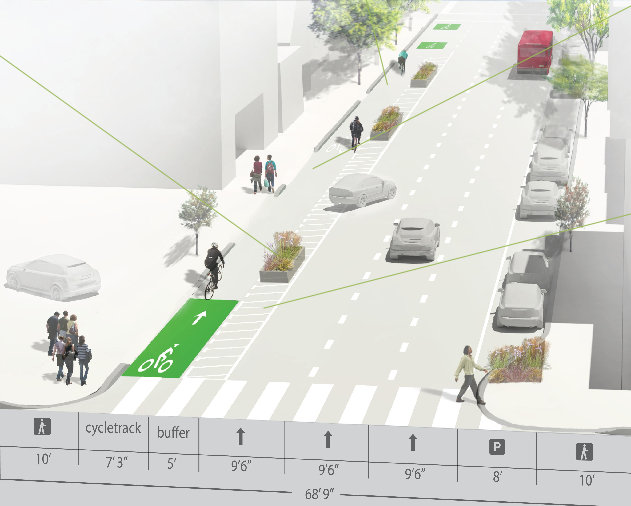
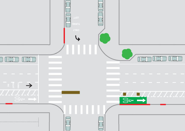
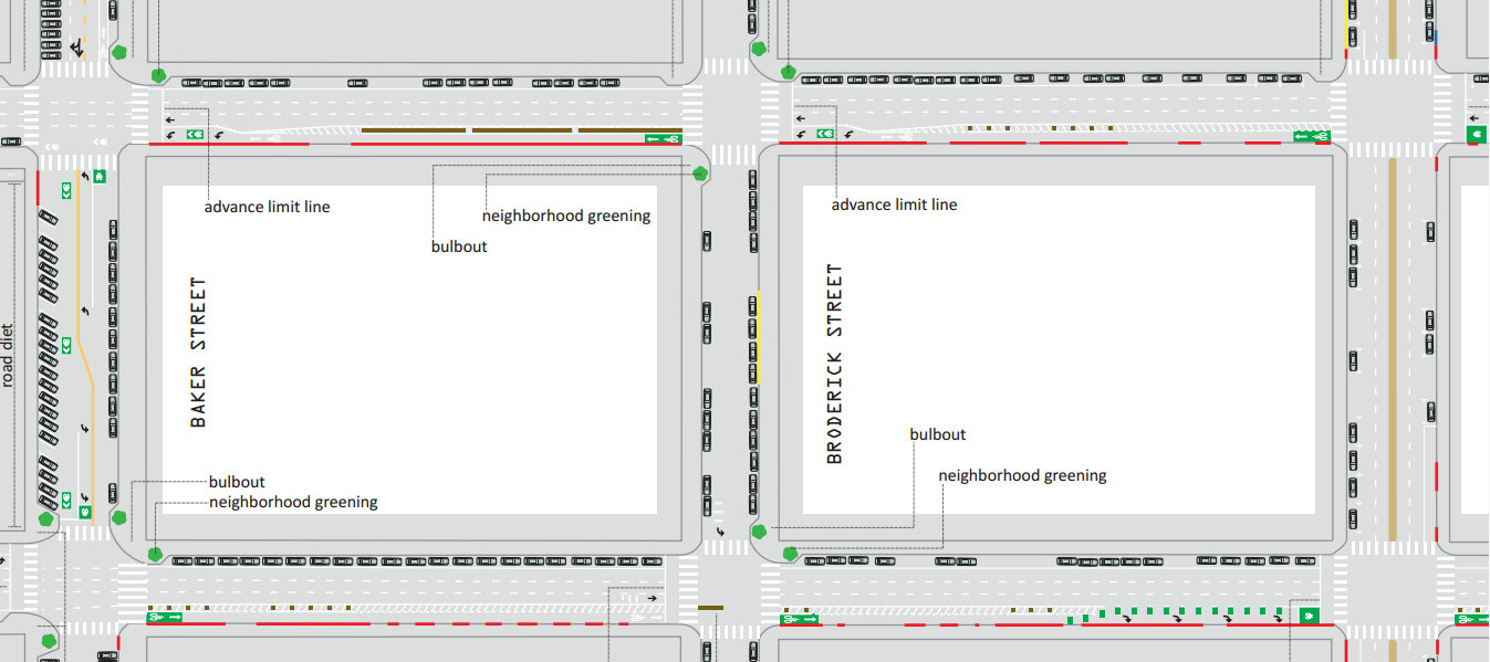
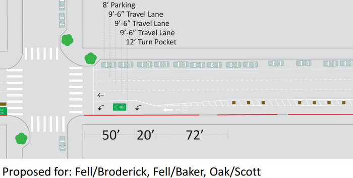
The SFMTA revealed the design [PDF] for protected bike lanes on three blocks of Fell and Oak Streets at an open house on Saturday. The plan would create a safer connection from the Panhandle to the Wiggle by installing a one-way buffered bike lane on each street, partially separated from motor traffic by planters. The proposal would also paint green markings where bike traffic merges with turning motor traffic, re-calibrate the traffic signals for 20 MPH movement, construct pedestrian bulb-outs and zebra-striped crosswalks, and add angled car parking spaces (mostly on Baker Street) to replace over half of those removed to make way for the bikeways.
Leah Shahum, executive director of the SF Bicycle Coalition, said the organization is “encouraged to see the city officially proposing wider, physically separated bikeways on Fell and Oak Streets” and “grateful to see that the design includes many new corner, sidewalk bulbouts that will make it easier and safer for people to walk across these intimidating streets.”
“We believe the designs shared at the community workshop should move forward and be implemented to make it safer for the thousands of people who bike this corridor every day,” she said.
Although in January the SFMTA set the implementation timeline for next winter, staff said it has again been pushed back until spring, almost a year later than the city originally predicted. The SFMTA asserts that the project is on schedule according to the new timeline.
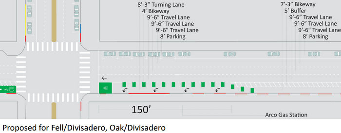
The plan uses green pavement treatments to emphasize a number of bike markings, including bike boxes, “super” sharrows where bikes and cars mix, and bike lane “entrances” at the beginning of each block. The approach at the intersection of Fell and Divisadero Streets, where green markings have already been added to reduce conflicts with drivers queuing up for the Arco gas station, would remain mostly as it is, though a bike box would be added.
At Oak and Broderick Streets, drivers would be prohibited from turning right across the bike lane onto southbound Broderick using a physical barrier. That would also prevent through-traffic on Broderick from crossing Oak in the southbound direction.
Turnout at Saturday’s open house wasn’t as robust as at December’s meeting, but comments from attendees seemed overwhelmingly supportive of the project. Still, a few critics seemed to keep staff and other supporters busy fielding complaints about the perceived trade-off of losing car parking — the main reason the agency ditched the original idea of implementing the bikeways as a trial this June.
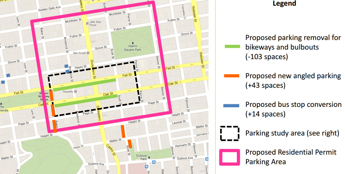
Under the proposed plan, 57 of the 103 parking spaces displaced by the bike lanes would be replaced, mostly by converting existing parallel parking spots to back-in angled parking and perpendicular parking, mostly along the west side of Baker Street between Fell and Haight Streets. The real estate for those spots would come from excess road space on Baker. In a post on the Panhandle Park Stewards blog yesterday, Dale Danley argued that the added parking “would make the entrance to the Panhandle less attractive, from the vantage point of anyone traveling along Baker St or approaching from the east.”
Fourteen more parking spaces would be created on Hayes Street by removing bus stops at Broderick Street and Central Avenue, which could also speed up travel times on the 21-Hayes line.
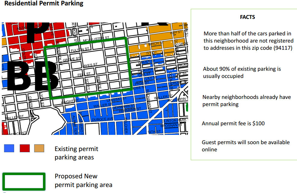
SFMTA staff also provided a form for residents to petition for the creation of a residential parking permit (RPP) zone on their block, which would give residential car owners priority for curbside parking by imposing restrictions on non-permit holders. A block can only be added to an RPP zone with signatures from 51 percent of the residents. Roughly 120 paid parking spots were also opened for overnight parking at the Department of Motor Vehicles last year.
To implement the project, staff said the SF Planning Department must complete environmental review, which would then need approval from the Planning Commission. He also said an SFMTA public hearing on the project will likely be held in May, although no decision would be made then. The project would then need to be finally approved by the SFMTA Board of Directors.
“Given how many people are biking and walking on these stretches of street — despite how intimidating they are without proper facilities for biking and walking,” said Shahum, “we hope the city will conduct the environmental review with all due haste and get these important safety improvements on the ground by this fall.”
Stay tuned for more details on the implementation process.

Read More:
Streetsblog has migrated to a new comment system. New commenters can register directly in the comments section of any article. Returning commenters: your previous comments and display name have been preserved, but you'll need to reclaim your account by clicking "Forgot your password?" on the sign-in form, entering your email, and following the verification link to set a new password — this is required because passwords could not be carried over during the migration. For questions, contact tips@streetsblog.org.