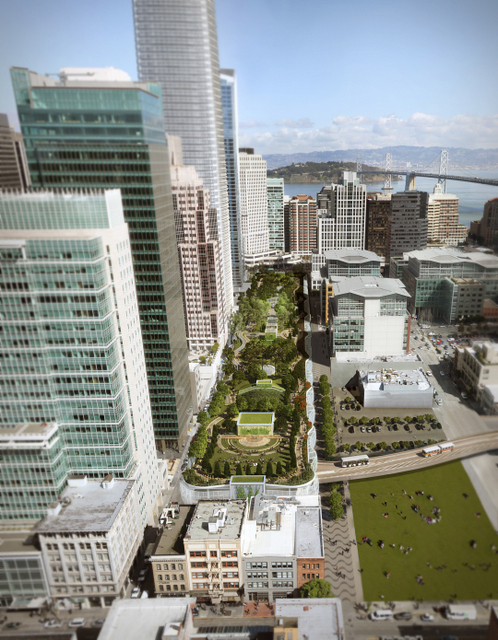
The new Transbay Transit Center is expected to transform San Francisco's downtown core by focusing new development around a massive regional transit hub in eastern SoMa. Scheduled to open in 2017, it will link 11 transit systems and eventually CA High-Speed Rail. Some have called it the "Grand Central of the West."
The SF Planning Commission last week approved an influx of high-density office and housing redevelopment, including the West Coast's tallest skyscraper, in the neighborhood surrounding the new station at First and Mission Streets, known as the Transbay Center District. To ensure that new workers and residents come by transit, foot, and bike instead of clogging the streets with cars, the plan would make sweeping streetscape improvements and limit the amount of car parking in the area.
"This is going to be one of the best examples of transit-oriented development in the world," said Gabriel Metcalf, executive director of the SF Planning and Urban Research Association (SPUR). "We're going to be putting in $4 billion in transit infrastructure and then putting our tallest buildings right on top of it. It's going to be studied and emulated all over the world if we get this right."
The hub, which replaces the old Transbay Terminal, would connect to transit systems in all nine Bay Area counties, including Muni, BART, AC Transit, SamTrans, and Golden Gate Transit. Caltrain would operate on an electrified system connecting directly to the station, thanks to a recently-approved plan to extend tracks from the 4th and King station. Caltrain would share those tracks with high-speed rail trains.
Streets within the plan area -- bounded by Market Street to the north, Steuart to the east, Folsom to the south, and just short of Third to the west -- would be transformed with improvements for walking, bicycling, and surface transit.
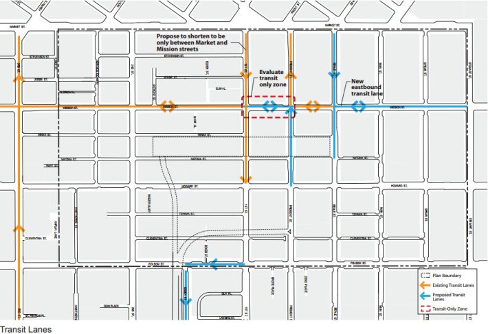
Major streets -- Mission, Howard, New Montgomery, Second, First, and Fremont Streets -- would get wider sidewalks, road diets, transit lanes, and boarding islands. The planning department is also looking at creating a transit-only plaza on Mission between First and Fremont.
The plan would also create several "Living Streets" engineered for calmer motor vehicle traffic on blocks of Spear, Main, Beale. These blocks would be characterized by fewer vehicle lanes, "significantly" wider pedestrian space on one side, and amenities like bike-share stations, café seating, and retail kiosks. Alleys in the area would also be pedestrianized to help relieve crowding on more congested streets, and an underground tunnel underneath Beale may connect the transit center to BART and Muni's Embarcadero Station.
New open spaces would be created around the station, including a 5.4-acre park on top of the transit center.
Walk SF Executive Director Elizabeth Stampe said the plan seems like "a great way to create streets where pedestrians truly have priority where so long pedestrians have been at the very bottom of the totem pole."
"South of Market is such a dangerous and unwelcoming area to walk now, and if we're going to put this major transit center here, we've got to reconfigure the streets to make them better for walking," she added. "This is a promising start."
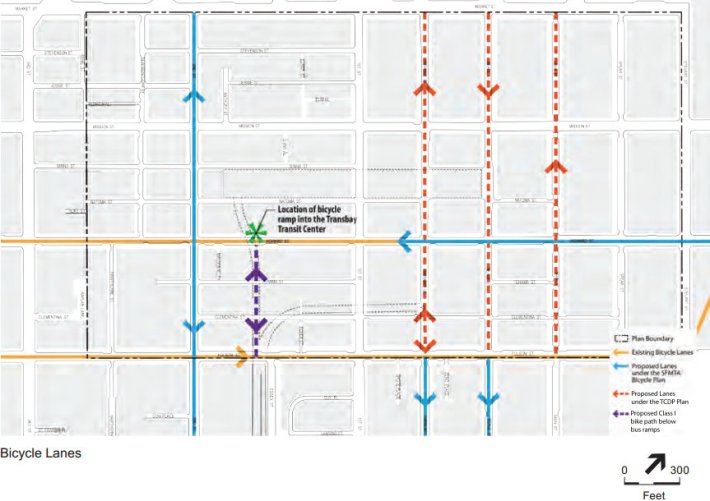
Bike improvements include a block-long, off-street bike path from Folsom to Howard (between 1st and 2nd) feeding a bike ramp directly into the transit center. Conventional bike lanes would also be added to Fremont, Beale, and Main Streets between Market and Folsom, with a bike box at Beale and Howard.
In another bid to reduce congestion from single-occupant vehicles, the plan would facilitate "casual carpooling," already a regular practice for Bay Bridge commuters, by creating designated waiting areas on some streets.
On top of improvements for car-free travel within the area, limiting the amount of parking is also crucial to avoid inundating downtown with more cars, said Joshua Switzky of the SF Planning Department.
"Limiting the supply of parking in downtown has been the most effective tool in limiting congestion as downtown has grown over the past several decades," Switzky told the Planning Commission last week. "While we can provide all the public transportation options that we can afford, if we don't limit parking supply, that will work against us."
Parking maximums in the district now cap space set aside for car storage at 7 percent of a building's gross floor area. The current reform plan proposes reducing the maximums by 50 percent, but it might go farther. Switzky said the percentage-based cap could be switched out for an absolute cap, since percentage-based caps "scale infinitely" regardless of a building's height.
"If we don't change those rules as we're proposing, there could be over 2,000 spaces built in this transit core," said Switzky. The district-wide cap -- a first for San Francisco -- would be determined by a study based on targets for limiting car trips and congestion, he said.
Livable City Executive Director Tom Radulovich praised the absolute maximum, saying it would close loopholes often used by developers to build excessive amounts parking in projects like the City Place mall planned in mid-Market. "Unless you really limit office and commuter parking, you're not going to get the traffic reduction you need to make the streets safe and livable," he said.
The cap, along with other progressive planning regulations in the Transbay District, should be expanded to consistently enhance the public realm throughout downtown, Radulovich said.
"The fact that it has a pretty complete streetscape plan -- they're looking at a lot of sidewalk widening, bicycle improvements, transit improvements -- is huge," he said. "Taking on that corner of the SoMa grid, and really beginning to calm those streets, is really positive, and it's something we'd really like to see extended to the rest of the SoMa grid. Putting pedestrians and cyclists and transit first on SoMa streets ahead of the automobile -- that's long overdue."
