East Palo Alto Begins Design Process for Bike/Pedestrian Overcrossing
This is part two of our series on the proposed bike and pedestrian overcrossing in East Palo Alto. You can read part one here.
During the public outreach for the proposed bike and pedestrian overcrossing in East Palo Alto, residents made clear to city planners and consultants that their main concern is safety. For decades, west side residents have been forced to cope with freeway traffic and congested intersections when they walk or bike to the grocery store or school on the east side.
“There’s a lot of traffic that comes through the city, both north/south and east/west,” said Casey Hildreth of Alta Planning + Design, which was hired by the city to design the overcrossing. “An alignment that can connect the community and really avoid as much traffic as much as possible is first and foremost our top priority.”
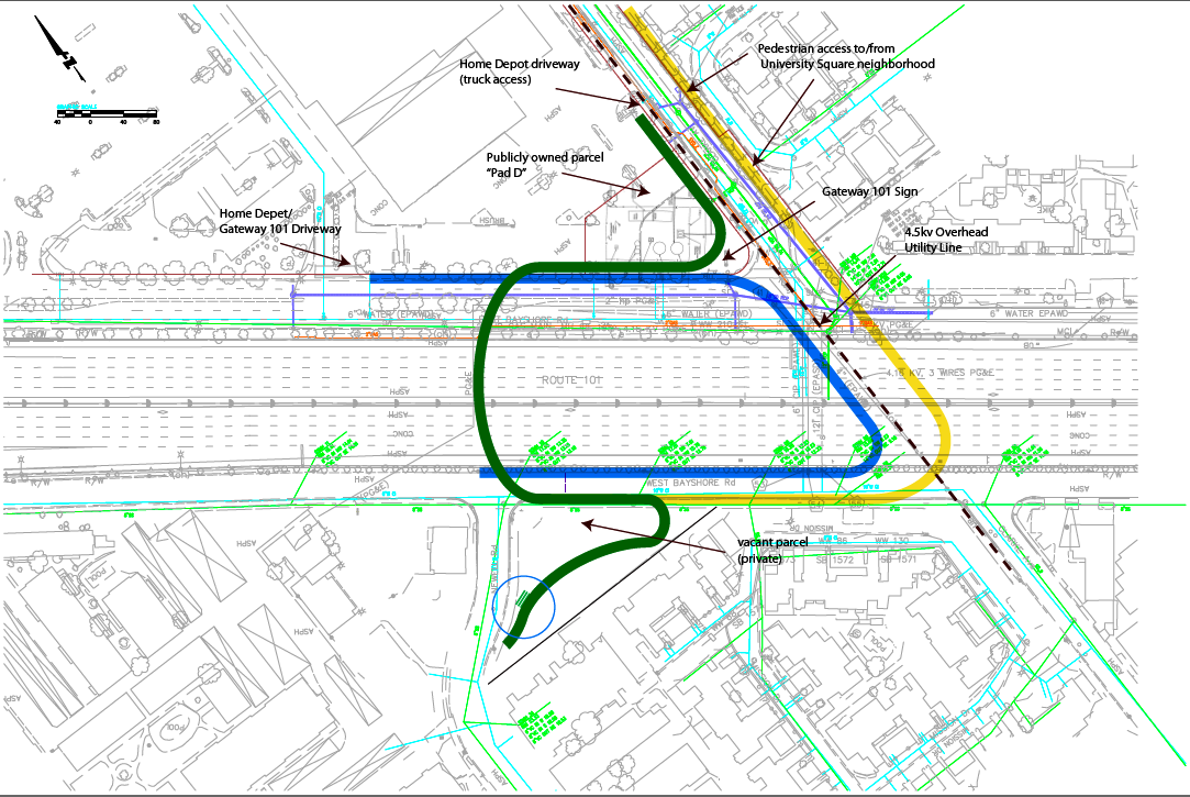
The bridge, expected to facilitate between 180,000 and 230,000 new biking and walking trips annually, would connect east to west over Highway 101 south of University Avenue. On the east side the access point would be in the vicinity of Clark and East Bayshore roads, and on the west side the landing would be on Newell Road.
Before the city can really focus on the design, it has to agree on an alignment. That is complicated by the fact that East Palo Alto is in the midst of a water crisis, said Hildreth, and the area where the city wants to build the overcrossing has been identified as an ideal location for water wells and towers. How, for example, would the city integrate a 76-foot-wide water tower?
“We’re working with city engineering staff to understand the contraints and requirements for those types of facilities and seeing if on either side of our bridge we can accommodate that,” Hidreth explained.
The city has narrowed down the possible alignments to three that provide the most direct connections to schools and services, and will begin a community process in December to get feedback on which one works best. The city is also conducting a survey of schools and collecting feedback from parents.
The Design
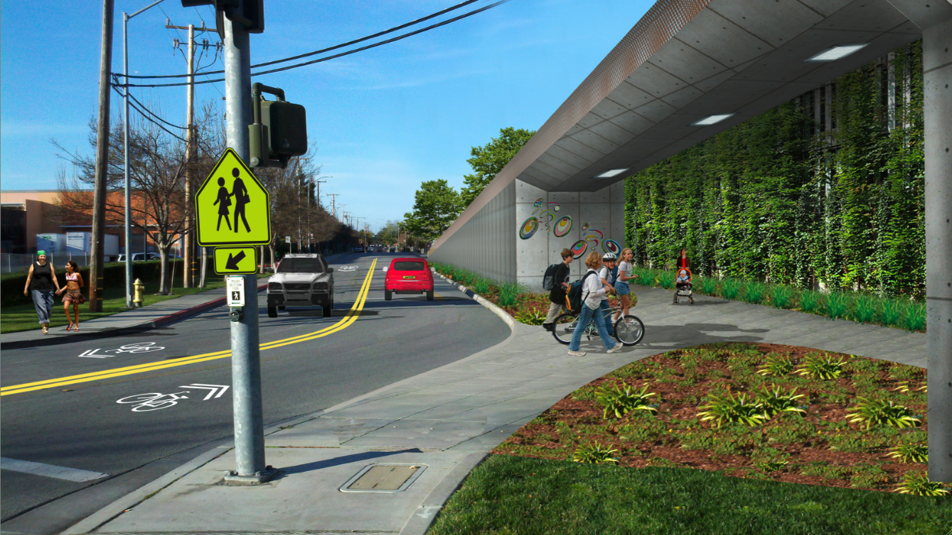
Other freeway bridges in the Bay Area offer inspiration and ideas: Berkeley has a landmark bike and pedestrian bridge over Interstate 80, and Belmont has a children’s bridge over Highway 101 that was designed using input from local students.
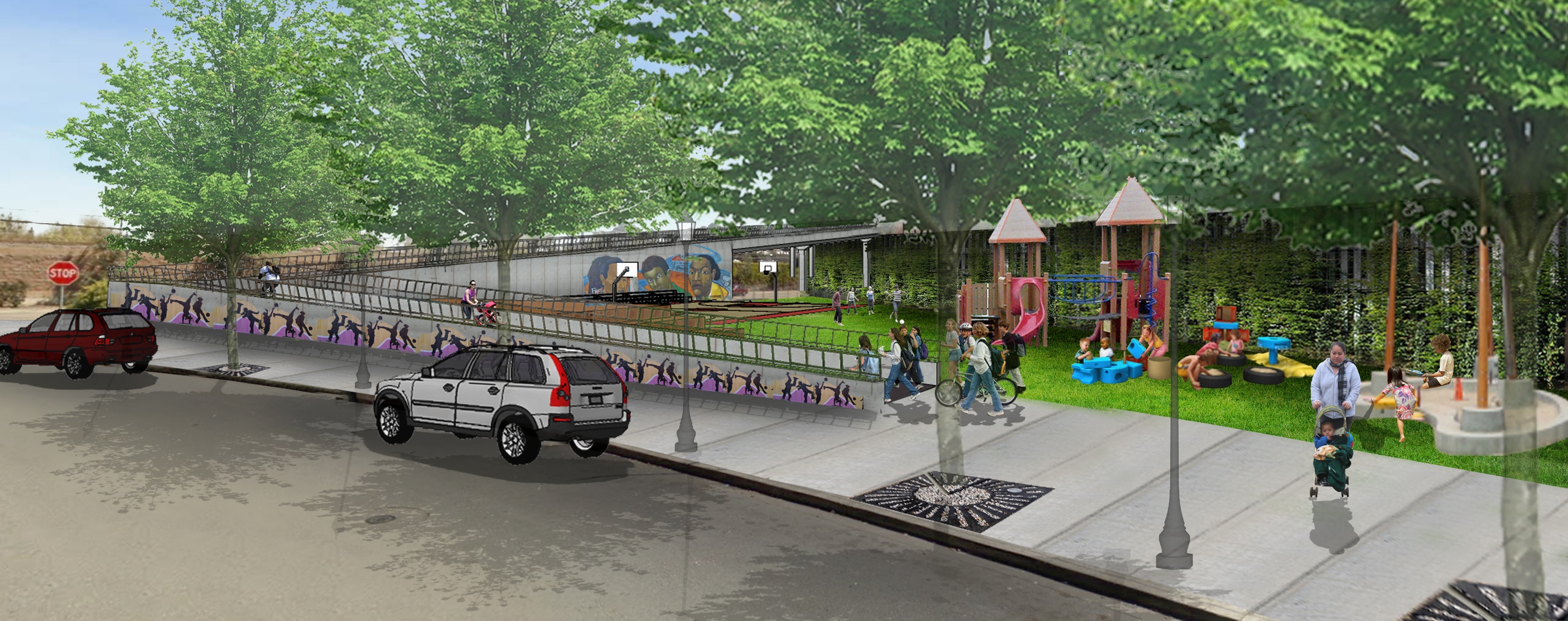
The most important thing to keep in mind about the bridge, Hildreth said, is that it meets the needs of the community, keeping in mind public safety. “We know we’re doing it in a community that’s very sensitive to public safety concerns and issues,” he said. Considering that there is a lack of public space on the west side of the freeway, one of the ideas that’s emerged is to include a park in the landing on Newell Road.
“The idea of supporting a positive activation mechanism like a park would I think be very conducive to supporting the type of activity we expect on this bridge,” Hildreth said, “with the elderly using it for recreation, with young kids potentially being sent to school on their own, older elementary kids and middle school kids and evening access to the grocery store and community services.”
The park could also include a children’s slide integrated into the bridge structure and a basketball court. Alta plans to create full-scale three-dimensional models for public meetings, as well as an online interactive tool in multiple languages using Google Earth. Hildreth stressed that planners are very early in the design process and won’t have renderings that accurately reflect community feedback until early next year.
Funding
East Palo Alto City Council Member Carlos Romero said the city recently won some grants, including $150,000 from Facebook, to update its general plan. The process will consider the future of the west side, including the design of the bridge and whether the project should include a park. “What are the things we need to include that make the west side a much more livable, walkable, bikeable place?” he said.
Early estimates peg the cost of the bridge at $6 to $8 million. It’s hoped it will be built in two or three years. Romero was instrumental in securing a $300,000 grant from the San Mateo County Transportation Authority for the design work and is confident that funds to build the bridge will be secured.
“In real estate development they say having title control or site control to the land is 90 percent of the deal,” said Romero. “In transportation work, at least in local transportation work, what’s important is having the design completed, and so without the design it’s virtually impossible to shop the project.”
“I’m much less worried now that we’re not going to get the money,” he added.

Streetsblog has migrated to a new comment system. New commenters can register directly in the comments section of any article. Returning commenters: your previous comments and display name have been preserved, but you'll need to reclaim your account by clicking "Forgot your password?" on the sign-in form, entering your email, and following the verification link to set a new password — this is required because passwords could not be carried over during the migration. For questions, contact tips@streetsblog.org.