Track Transportation Projects With the SFCTA’s New “MyStreetSF” Map
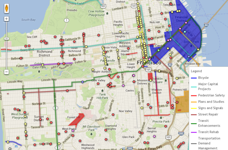
The SF County Transportation Authority recently launched an interactive Google map that shows ongoing transportation projects throughout San Francisco all in one place.
MyStreetSF.com lets users search for traffic calming projects, pedestrian safety upgrades, bike lanes, transit lanes, traffic signal upgrades, and even BART/Muni escalator rehabs. Users can search with a number of filters, including by neighborhood, supervisor district, project type, funding source, and timeline.
Maria Lombardo, interim executive director of the SFCTA, said the map is aimed at helping the public become familiar with smaller transportation projects, which tend not to get as much exposure in the media as major ones. “Most people are familiar with the very large capital projects like the Central Subway or the Transbay Terminal,” she said. “But half of our programs are things happening in the neighborhood that can happen very quickly.”
Not all of the city’s transportation programs can be mapped — for example, bike education classes, commuter benefits programs, and rideshare matching services. Information on those programs is listed below the map.

Read More:
Streetsblog has migrated to a new comment system. New commenters can register directly in the comments section of any article. Returning commenters: your previous comments and display name have been preserved, but you'll need to reclaim your account by clicking "Forgot your password?" on the sign-in form, entering your email, and following the verification link to set a new password — this is required because passwords could not be carried over during the migration. For questions, contact tips@streetsblog.org.