East Palo Alto’s Highway 101 Ped/Bike Bridge Almost Fully Funded
East Palo Alto's decades-long dream to reconnect its east and west sides via a pedestrian/bicycle bridge has taken a huge leap forward. The California Department of Transportation (Caltrans) approved the city's $8.6 million application to construct a 12-foot wide bridge over Highway 101 between Newell Road and Clarke Avenue, following East Palo Alto's City Council's June allocation of $600,000 for environmental review and design.
The bridge is the second-most expensive project recommended for Caltrans funding statewide, out of 145 ped/bike projects that will receive $221 million over the next two years from the state's new consolidated Active Transportation Program. (The top-dollar project is $10.9 million for environmental studies and land acquisition for the Coachella Valley Link, a 50-mile long "mostly continuous" multi-use path in Riverside County.)
University Avenue, which runs roughly north-south across the center of East Palo Alto, crosses Highway 101 and continues as Palm Drive through downtown Palo Alto and Stanford University. University Avenue's 1950's-era, auto-centric highway interchange design, complete with high-speed loop ramps and six-lane intersections on both sides, practically ensures danger for pedestrians and bicyclists. Anyone on foot or bike must cram into one narrow sidewalk, on the north side of the bridge over Highway 101, since no sidewalk was ever built on the bridge's south side, and no bike lanes have never been striped within the street.
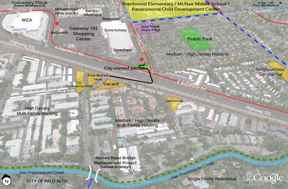
The East Palo Alto Highway 101 Ped/Bike Overcrossing, to use its official name, will provide a safe alternative one third of a mile to the southeast, and shorten the distance between the densely populated Woodland neighborhood west of the highway and the Ravenswood 101 Shopping Center on the east. Shopping trips to Mi Pueblo, the city's only grocery store, will be faster for many residents by bicycle or even on foot than in a car, since drivers will still have to pass through a total of seven heavily trafficked signals to make the one-mile trip.
Several schools located on nearby Clarke Avenue will suddenly become accessible on foot or by bike for the many children living west of the highway. And Newell Road, running due south from the shopping center and the future ped/bike bridge, connects directly to Palo Alto's high-quality network of bike lanes and bicycle boulevards.
The bridge "will enhance public safety, promote walking and bicycling, and reduce vehicular trips on University Avenue and other congested roadways," stated the introduction to the bridge project's $300,000 feasibility study, completed last year by Alta Planning + Design. "The project will also improve community health by providing recreational opportunities and linkages to the Bay Trail and City of Palo Alto."
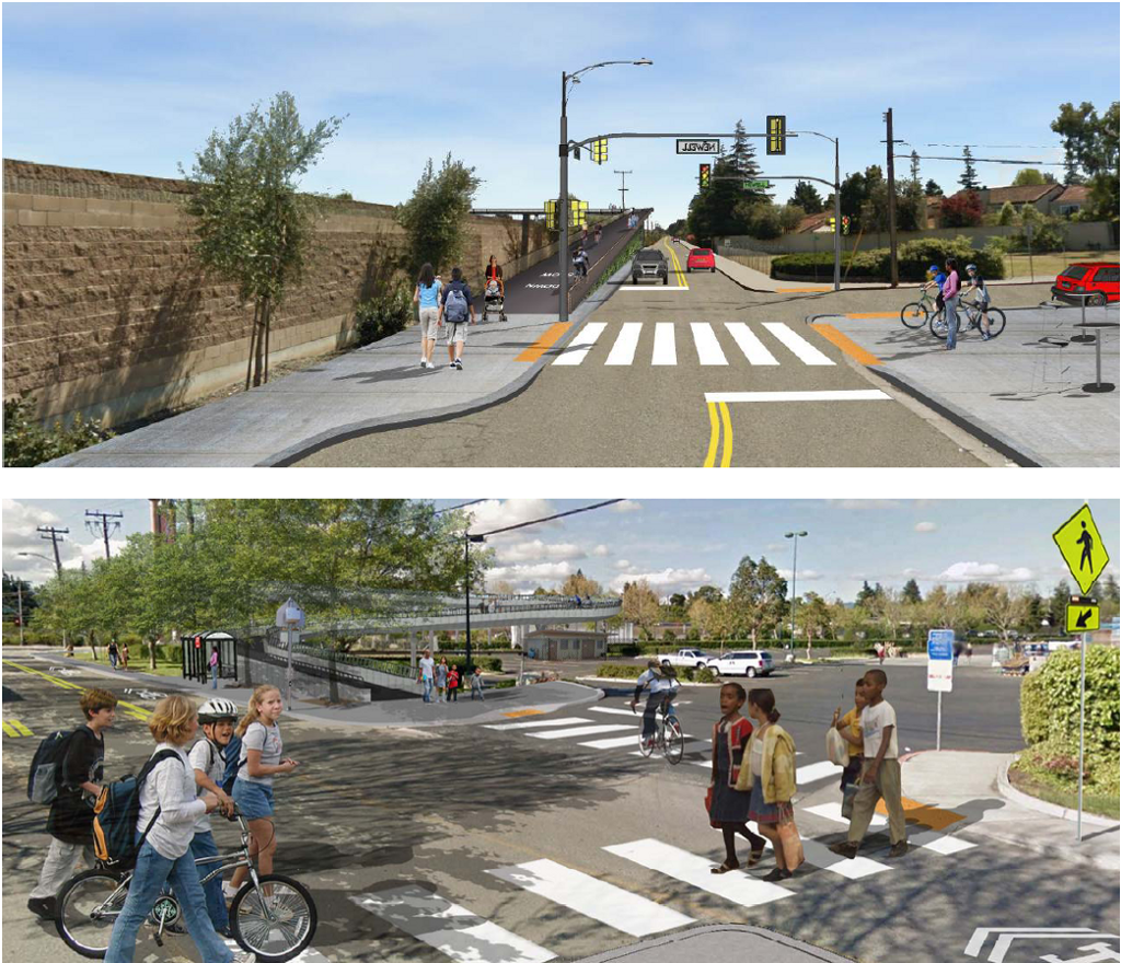
City officials have chosen Alignment 2A from the feasibility study's design options for the bridge's ramps. At last year's city council review of the draft feasibility study, city officials were hopeful that the bridge's western ramp could, together with a privately-owned triangular parcel at the end of Newell Road, become a new city park.
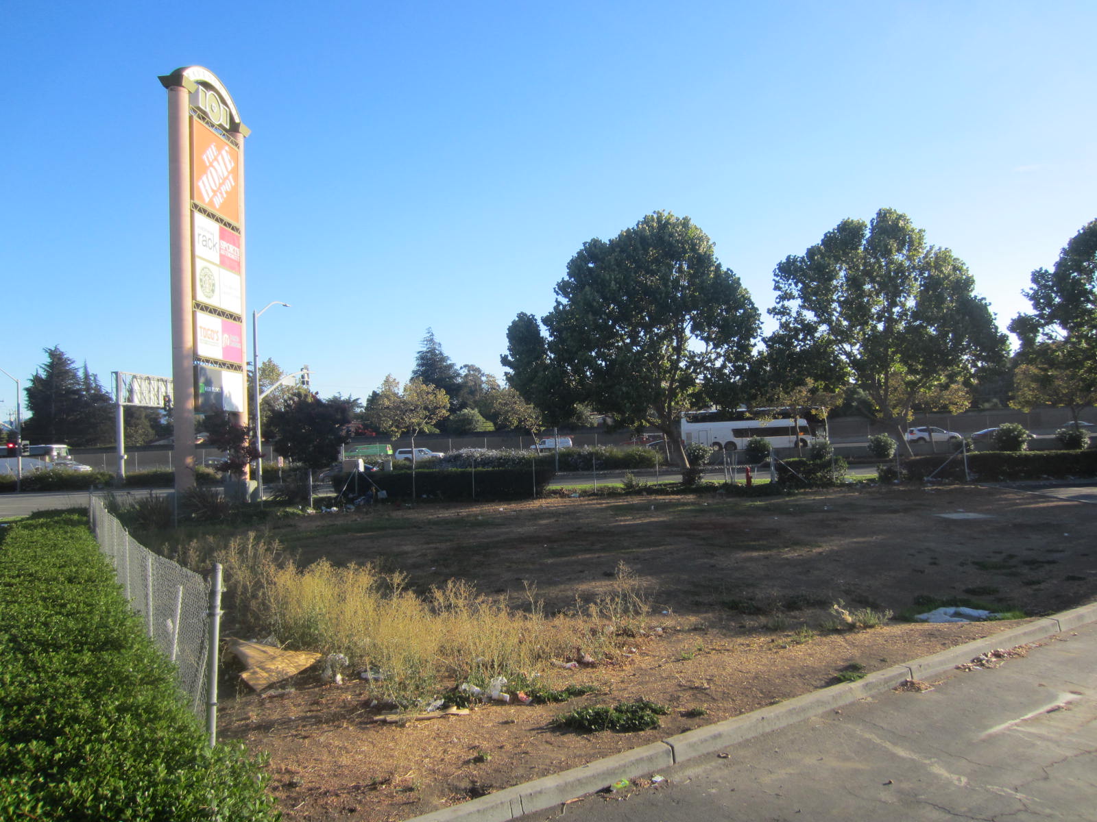
But Alignment 2A uses only city-owned land for the bridge's ramps, which avoids the need to purchase additional land. The western ramp will run straight along the existing sound wall on West Bayshore Road, similar to existing ped/bike bridges over Highways 101 and 237 at Borregas Avenue in nearby Sunnyvale. The eastern ramp will include several curves, as it will be confined to city-owned land at the southeast corner of the Home Depot parking lot.
Competition was stiff for the grants, with Caltrans funding fewer than one in five of the projects submitted. East Palo Alto's bridge project scored 89 of 100 points by the judges, who included "stakeholder volunteers with expertise in bicycling and pedestrian transportation" and Caltrans staff. This was 18th-highest out of the 56 "non-Safe Route to Schools" projects recommended for funding, and well above the cut-off score of 80 points.
After clearing the last funding hurdle -- the California Transportation Commission's review of the ATP recommendations on August 20 -- East Palo Alto's bridge will require about a year of environmental review and engineering. Utility lines on both sides of Highway 101 will have to be moved underground by PG&E before construction can begin, and the bridge should be completed in 2019.
Stay in touch
Sign up for our free newsletter
More from Streetsblog San Francisco
Commentary: Merchants Are Getting People Killed
The number one local obstruction to curbing traffic violence is local commerce and merchant groups.
Supervisor Melgar Betrays Promises, Sells Out Family Killed in West Portal
Well that didn't take long