East Palo Alto Considers Options for Bike/Ped Bridge Over Highway 101
The dream of reconnecting the two halves of East Palo Alto divided by Highway 101 with a bicycle/pedestrian bridge moved one step closer to reality last month with the release of the project’s draft feasibility study [PDF].
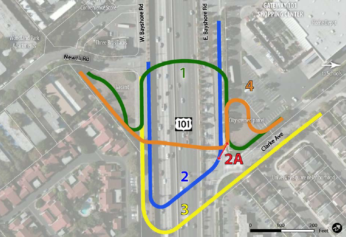
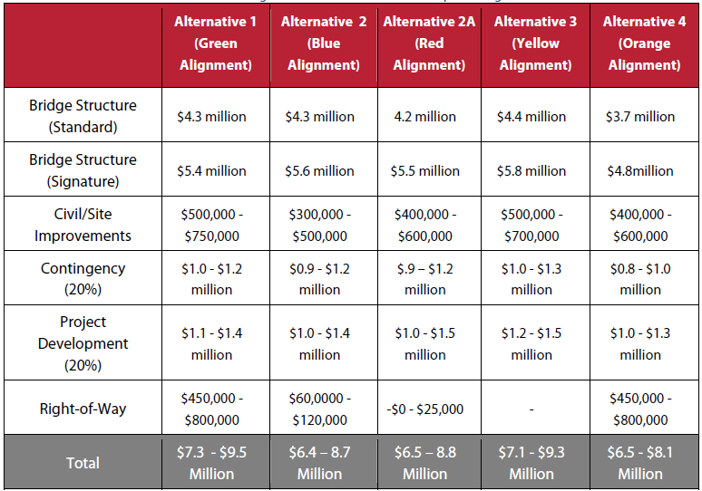
Alta Planning + Design, which conducted the $300,000 study, examined five different possible alignments for the bridge, which are estimated to cost between $6.5 million and $9.5 million to design and construct. According to Alta’s estimates, the bridge would be used for 130,000 to 230,000 trips per year (350 to 630 per day) — an unusually high volume for bike/ped bridges due to the dense residential and commercial development on either side of the highway.
EPA City Council members who reviewed the study at a meeting last Tuesday didn’t indicate a preference for any of the bridge designs, though all four of those present voiced their support for the project (one, David Woods, was absent).
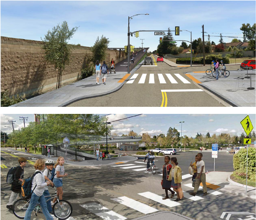
“The current overpass over the 101 freeway is not safe,” said Council Member Laura Martinez. “I see this project as a solution to get our residents across town. This is a major connection for our residents to get to schools, shopping, our grocery store. This overcrossing encourages walking and biking.”
When planners gathered input on the project at a series of community meetings last year, “issues of traffic safety rose immediately to the top,” said Alta’s Casey Hildreth.
As Mayor Ruben Abrica noted, East Palo Alto is one of the last Peninsula cities divided by Highway 101 to receive a bicycle/pedestrian bridge. “There has been a pedestrian bridge in Menlo Park, there has been a pedestrian bridge in Palo Alto, for many years. We are the only ones who don’t have one,” he said. “It’s good for business, it helps children get to school, it connects us more to the surrounding communities, and to the Bay.”
On the west side of 101, the various options would either place the bridge ramp along West Bayshore Road (a frontage road) with the entrance at Newell Road, or on a vacant, privately-owned parcel where the two roads intersect.
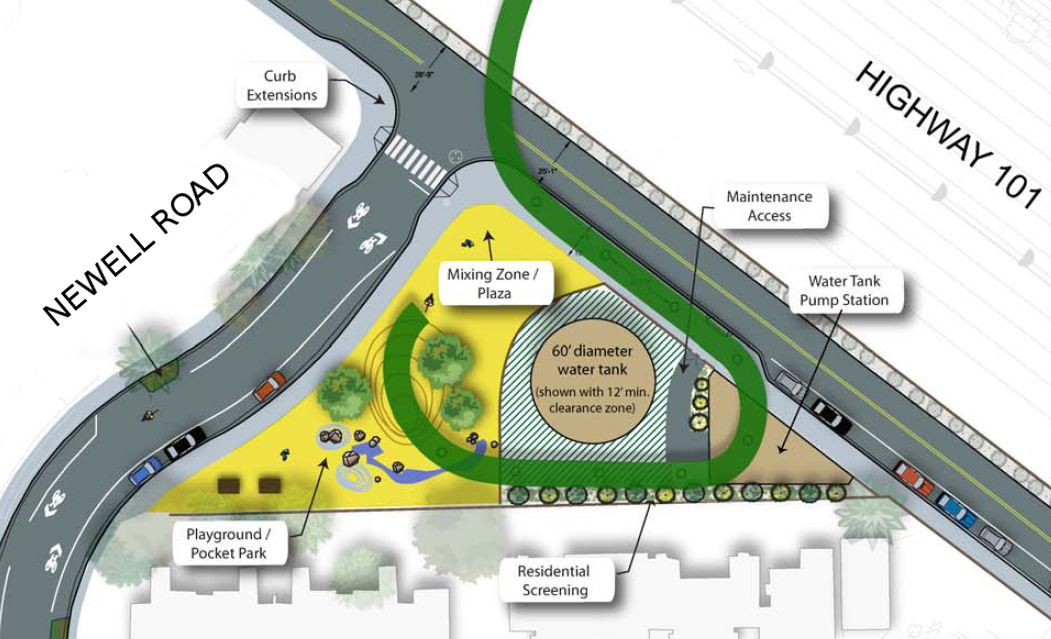
Placing the western ramp on the vacant parcel would allow the city to create a new public park there — the first in East Palo Alto on the west side of 101. The parcel was also recommended as a potential location for a future water well and storage tank that the city aims to build.
However, that land is owned by the Young family, which told the City Council that they are not interested in selling it to the city. Ken Young explained that since 1955, the city has already invoked eminent domain twice in order to make room for the highway and for Newell Road, destroying his family’s flower business. “This cut our property in half, making it impossible to grow flowers,” he said.
Planning Commissioner Bernardo Huerta said the city should avoid acquiring private land for the bridge project because “that will trigger a price war. It’ll be property you can’t afford.”
Placing the ramp on the frontage road would avoid delays and costs associated with acquiring private property. The three most recently constructed bike/ped bridges nearby, over Highways 101 and 237 at Sunnyvale’s Borregas Avenue (built in 2009), and over 101 at Menlo Park’s Ringwood Avenue (built in 2012) make use of frontage-road ramps on both sides.
All the options analyzed by Alta include a 12-foot-wide bridge — the same width as the bike/ped bridges over Highway 101 in Burlingame at Broadway and the one built over Highway 280 in Cupertino at Mary Avenue — both of which opened in 2009.
Of the five alternatives, Alta recommended two — known as Alignment 1 and Alignment 4 — that include portions which exceed the maximum 5 percent slope recommended by Caltrans to ensure accessibility for children, seniors, and people with disabilities. These designs would use the same land for the bridge entrances: the private parcel at West Bayshore Road and Newell Road for the western ramp and a small city-owned parcel at East Bayshore Road and Clarke Avenue for the eastern ramp. Alignment 1 would be longer and less steep than Alignment 4, and would require the removal of 18 to 20 parking spaces because its ramps would stretch along the frontage roads in order to reduce its slope. Alignment 4 might entail removing one or two parking spaces for optimal column placement.

Another option, Alignment 2, would only use public land for the western ramp, includes frontage-road ramps and would be the least expensive to construct. However, it would require putting more of PG&E’s overhead power lines underground compared to other alignments, adding two to five years to the project’s timeline, according to the study.

Estimated construction costs range between $6.5 and $9.3 million, depending on the design. For each option, costs would increased as much as $1.4 million if the city opts for a “signature” bridge design, like the suspension bridges over I-80 at Berkeley’s University Avenue and Cupertino’s Mary Avenue bridge over Highway 280.
Construction is expected to take a year and a half and begin no sooner than 2018.

Read More:
Streetsblog has migrated to a new comment system. New commenters can register directly in the comments section of any article. Returning commenters: your previous comments and display name have been preserved, but you'll need to reclaim your account by clicking "Forgot your password?" on the sign-in form, entering your email, and following the verification link to set a new password — this is required because passwords could not be carried over during the migration. For questions, contact tips@streetsblog.org.