Behold the New Muni Map
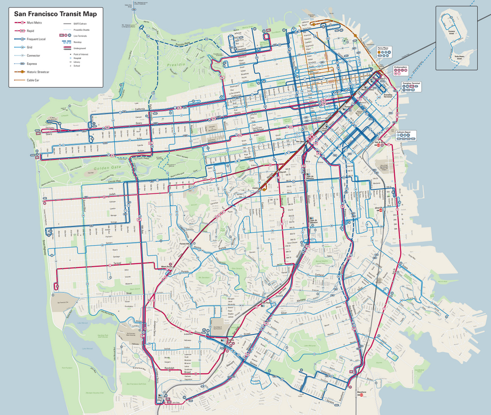
Tourists and newcomers, be daunted no more. Muni has unveiled its new map.
The complex web of San Francisco’s 82 municipal transit lines has been made more legible through a sleek new layout that will grace Muni shelters early next year. As we wrote in June, the map was developed over ten years by two volunteer cartographers, David Wiggins and Jay Primus, who also happens to be the former manager of SFPark.
The map “helps visualize the service hierarchy,” making it clear “where there’s more service, and where there’s less service,” as Muni’s operations planning and scheduling manager, Julie Kirschbaum, put it in June.
The map also incorporates service changes that streamlined some routes in recent years, such as the new contra-flow transit lane that straightens out the 6 and 71 lines on Haight Street, the new Muni-only left-turn lane for the 29 at Lincoln Way and 19th Avenue, and the two-way traffic conversion at the end of McAllister Street which has sped up the 5. Muni will re-align routes and change frequencies on another 30-plus lines as part of the Transit Effectiveness Project.
The new map also uses an “R” designation for “Rapid,” instead of the traditional “L” for “Limited.” For instance, it lists the “38R” and the “5R” as routes heading out to the Richmond. The 28L is still listed, though it’s unclear if that was just an oversight.
If you want to get a closer, in-person look, the map is on display until February at SPUR’s Urban Cartography exhibit at its Urban Center at 654 Mission Street. A high-resolution version (11 MB) file of the map is available online.

Streetsblog has migrated to a new comment system. New commenters can register directly in the comments section of any article. Returning commenters: your previous comments and display name have been preserved, but you'll need to reclaim your account by clicking "Forgot your password?" on the sign-in form, entering your email, and following the verification link to set a new password — this is required because passwords could not be carried over during the migration. For questions, contact tips@streetsblog.org.