For years, Akron, Ohio, has been planning to dismantle a nearly-empty highway through its downtown. Now that work is underway, the city has an open-door policy to figure out what to do with the land -- and Akronites are coming up with all sorts of ideas.
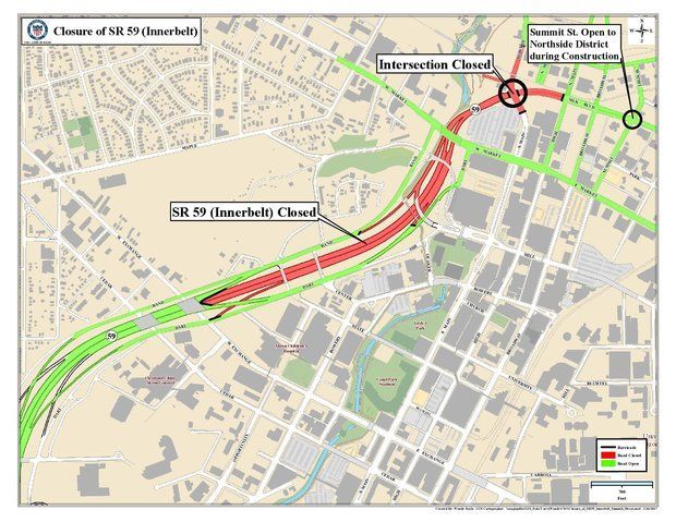
The Innerbelt, or State Route 59, is a spur highway from Interstate 76 to downtown Akron. Built in 1970 to pump cars into downtown just as the city began losing population, its three lanes in each direction are usually empty. In February, after years of planning, the Ohio Department of Transportation began tearing down the final mile of the highway, closest to the heart of downtown. Work is expected to finish next year and the city is negotiating to take over the land from the state.
“We’ll be reclaiming about 30 acres in the middle of the freeway, which is going to be a great opportunity," said Jason Segedy, Akron's director of planning and urban development. “We don’t really have anything concrete yet that we will be using it for.”
Some developers have expressed interest, but before the city decides whether to sell land to the highest bidder, it's encouraging Akronites to come up with ideas -- many of which are being supported by the Knight Foundation, which was founded in Akron. Its headquarters moved to Miami in 1990, but the foundation still funds initiatives "to strengthen Downtown Akron and surrounding neighborhoods."
Locals also hope that a new wave of civic leadership will be open to acting on their ideas. After a few tumultuous years, Akron has a new mayor, as well as new leadership at its big hospitals and university. There's a feeling that the city can turn the page.
"There’s this new wave of optimism," says Craig Thompson, who runs an architecture firm downtown.
Last year, students from the Cleveland Urban Design Collaborative came up with ideas for the space by hosting a three-day charrette. And last weekend, Thompson's firm hosted its own charrette at Kent State University about what to do with the Innerbelt. About two dozen people showed up.
In addition to creating parks and public space, the group was interested in memorializing touchstones of the majority-black neighborhood that was demolished when the highway was built. The West Hill neighborhood's razed jazz clubs, for instance, could be commemorated with plaques or live performances.
Today, West Hill is separated from downtown by the Innerbelt. “When the freeway was built, it tore apart this neighborhood and created a deep divide," says Hunter Franks, an artist who hosted a 500-person dinner on the Innerbelt almost two years ago.
"As part of the project, we had a giant piece of butcher paper that ran the length of the table and we asked people for their ideas,” he says. “Overwhelmingly, people said they wanted to see some sort of space for public use and some sort of green space."
Franks is hoping to get to work soon, asking people what they want from what he is calling the Innerbelt National Forest, a space that would open next summer as a three-month trial. The project was announced as a finalist by the Knight Foundation earlier this year. “The goal is to, after the three months are up, to take what we’ve learned and share that with the city and other folks to inform the long-term use of the space," Franks says.
The Innerbelt National Forest isn't the only idea on the table. Jonathan Morschl, who works for another architecture firm in Akron, came up with the idea of creating a mountain bike park and submitted it to the Knight Foundation's Cities Challenge. “When I originally submitted the idea, I didn't really know what a mountain bike park was,” he says. "I was trying to think about something the community would use."
Knight liked the idea, and gave him money to flesh it out. “The idea right now is to get something low-cost and temporary but thoughtfully designed that people can use,” Morschl says. “From there, maybe we expand it and do something more permanent.”
He's hired the International Mountain Bicycling Association to come up with a design for the park, which he'd like to try out next year where the Ohio & Erie Canal Towpath Trail crosses the Innerbelt.
That's also the location Franks is eyeing for his park. Can all these ideas coexist in one space? "Thirty acres is no small area," Franks says. “There’s lots of different projects and different folks working under the idea that prototyping and testing things first is valuable.”
“While there is, obviously, interest in that vacant land, it’s not going to be sold off to the highest bidder at this point," Morschl says. "So we have the opportunity to do something kind of unique.”


