Note: GJEL Accident Attorneys regularly sponsors coverage on Streetsblog San Francisco and Streetsblog California. Unless noted in the story, GJEL Accident Attorneys is not consulted for the content or editorial direction of the sponsored content.
A Marin County Supervisor, who represents San Rafael, apparently wants to look at nixing plans for the long-planned bike and ped path on the Richmond-San Rafael Bridge, according to a piece today in the East Bay Times. From the article:
Marin County Supervisor Damon Connolly, who sits on the Metropolitan Transportation Commission and the Bay Area Toll Authority, thinks new space on the top deck should be used for westbound [motor] vehicles. “This project is of particular significance for Marin and Contra Costa counties,” Connolly said at the Bay Area Toll Authority Oversight Committee meeting last week as the plan was reviewed. “Perhaps of no surprise to many in the room, we have heard significant criticism, not unjustified in my view, about the westbound bike lane on the bridge in terms of what is being perceived as a hefty price tag for the project versus likely usage by bikes. There seems to be a question mark about what that usage would likely to be.”
Orinda Mayor Amy Worth, who also sits on the Committee, echoed Connolly's comments.
Dave Campbell, Advocacy Director for Bike East Bay, which has been pushing for a bike path on the shoulder of the bridge for some 40 years, was at the meeting and took exception to the notion that the price tag was hefty. "Regional Measure 3 is going to the voters in June," he said in a phone interview with Streetsblog. If that measure passes, it will allocate, along with the monies going to the current bridge project, "$230 million for cars on the bridge and to deal with car-access to the bridge. I’ll defend spending $13 million on bikes versus $230 million for cars."
But Connolly, in a phone interview with Streetsblog, stood by his statements. "There’s justified concerns about the cost of the project versus likely usage by cyclists," he said, adding that congestion on both decks of the bridge keeps getting worse. It was unclear, however, what would constitute sufficient usage numbers of cyclists to justify keeping the bike and ped path.
Campbell added that any evaluation of bike-usage numbers would be unfair, since on the East Bay/Point Richmond side the bridge is cut off by a rail yard (I-580 travels over the rail yard, providing cars a way to continue east, but not bikes or pedestrians.) "It’s not a fair fight if we start measuring how many people use the bridge when there’s no good way to bike to the bridge." He added that proper connections between the bridge and the rest of the Richmond bike network also have to be built.
"I think that is an issue," agreed Connolly.
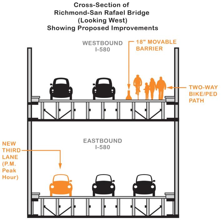
Campbell also rejected the notion, floated by officials from the MTC, that there might be a way to "share" the bike/ped path, by allowing it to be used by motor vehicles during peak periods, something Connolly said he would support.
Campbell added that, while he's a bike advocate, he was disappointed that nobody at the meeting was talking about transit improvements. "Here we are with the highest level staff from MTC, discussing a congested corridor, and nobody is discussing transit," he said. However, Connolly, at least in the follow up with Streetsblog, said he would support making the bike and ped lane into a bus-only lane, at least in principle. However, when asked if he would consider converting one of the existing car lanes into a bus-only lane, he said: "No, I’m not prepared to do that right now."
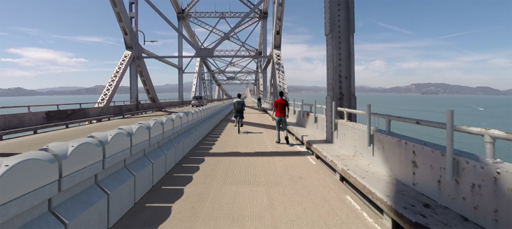
Officially, the $27 million project's bike lane component is a trial that could be converted to a car lane in a few years. It was back in February of 2016 that the Bay Area Toll Authority (BATA) Oversight Committee unanimously approved the trial of the ten-foot bicycle-pedestrian path on the Richmond-San Rafael Bridge. Connolly said that at the next meeting of the full MTC board, it's likely that a decision will be made on hiring a contractor to install the bike ped path on the bridge. This will include installing a movable barrier, similar to the one installed on the Golden Gate Bridge in January 2015, to make sure cars can't get onto the bike/ped space.
According to the project factsheet, the Richmond-San Rafael Bridge will connect the Bay Trail between Contra Costa and Marin counties for bicyclists and pedestrians, adding another link to the future 500-mile bicycle and hiking network. The path begins in Richmond at Castro Street and continues adjacent to westbound I-580 to Grange Avenue in San Rafael. The bike and ped path is supposed to open by the end of this year and is part of a larger project to increase bike commuting around the Bay and between Marin and the East Bay. State environmental documents were finalized in August of 2016.
Connolly has declared strong support for greenhouse gas reductions and says he is an avid cyclist. From the Supervisor's policy page: "The County has a key role to play in climate change issues on every level, from flood risk management to sea-level rise adaptation to aggressively scaling down our local carbon emissions." He told Streetsblog that bridge congestion, especially at the toll booths, contributes to pollution.
