Emeryville Approves 40th Street Protected Bike Lanes
Note: GJEL Accident Attorneys regularly sponsors coverage on Streetsblog San Francisco and Streetsblog California. Unless noted in the story, GJEL Accident Attorneys is not consulted for the content or editorial direction of the sponsored content.
Protected bike lanes and bus-only lanes were unanimously approved last week by the Emeryville City Council for the approximately one-mile stretch of 40th Street from the Oakland City line at Adeline Street to the entrance to IKEA. The project will have “Red bus-only lanes and pedestrian safety improvements. If I stopped right there, I’d say it’s already the best complete-streets project in the East Bay,” said Bike East Bay’s Dave Campbell in a phone interview with Streetsblog. But it doesn’t stop there: it’s also going to have a two-way protected cycle track and, going by the published documents, protected intersections at major streets.
Total construction costs come to between $18 and $20 million and the project is expected to take until 2023. However, Emeryville Councilmember John Bauters, who was a key advocate behind the approval, told Streetsblog that some of this is squishy and will depend on whether they can get bicycle-height crossing buttons, or sensors that will start the signal phasing if a bike approaches. Raising the cycle track to sidewalk-level is also a possibility as the details are ironed out.
And he’d like to have curb extensions/bulb outs that go two-car lengths, to keep sight-lines maximized to give cyclists ample opportunity to react to the “scourge of bad drivers” who pull out without looking. He added that he wants the lanes to be safe for families. Basically, he said, “I’d like to put in all the bells and whistles.”
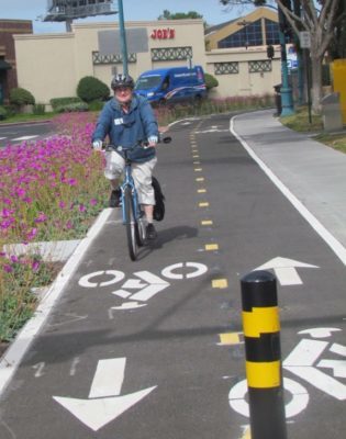
Of course, any improvements will be welcome by cyclists. Currently, 40th Street is intimidating. The street cuts across multiple strip malls with big-box stores, which are large traffic generators. The bike “infrastructure,” if one can even call it that, is stripes along the gutter and/or parking lane and curb, as seen below:
So what about the two-way cycle tracks, as opposed to having one-way cycle tracks on both sides of the street?
Two-way protected bike lanes generally aren’t the preferred design, at least according to Dutch traffic engineers. There are exceptions: two-way protected bike lanes are fine along, for example, Lake Merritt, since there aren’t any intersections and it makes for a pleasant cycling experience. In the case of 40th, however, Bauters said in the course of discussions with the Bicycle / Pedestrian Advisory Committee and Emeryville staff, they decided it made the most sense to have a two-way on the north side of the street. The argument: all the turning lanes and the traffic in and out of the shopping center on the south side just made for too many conflicts. Meanwhile, Bike East Bay has an entire page dedicated to some of these issues between two-way and one-way protected bike lanes.
Bauters is hoping Oakland will build similar treatments going east at least as far as MacArthur BART and that eventually Emeryville will continue building west, he hopes, to eventually continue along Shellmound Street to connect with the Bay Trail and the Bay Street shopping center.
As seen in the above diagram, there will also be bus-only lanes to help keep AC Transit and the Emery Go-Round buses on schedule. He said they looked at a “full BRT” style treatment, with bus lanes in the center and boarding islands, but ultimately decided it was too complicated and there was too much potential push back from Oakland to the east. Plus “…it would have increased the cost for us and put pressures on service providers over which we just don’t have control,” lamented Bauters.
For a full look at the design, check out the city documents online.

Streetsblog has migrated to a new comment system. New commenters can register directly in the comments section of any article. Returning commenters: your previous comments and display name have been preserved, but you'll need to reclaim your account by clicking "Forgot your password?" on the sign-in form, entering your email, and following the verification link to set a new password — this is required because passwords could not be carried over during the migration. For questions, contact tips@streetsblog.org.