In this year’s installment of its annual Highway Boondoggles report, U.S. PIRG Education Fund and Frontier Group warn of billions of dollars in proposed spending on unnecessary highway projects that would divide our communities, deprive transit of scarce funds, and pollute our air and water. In this bonus installment, Gideon Weissman and Matt Casale explore Boston, Mass. project that has Beantown at a crossroads between yet another car-centric boondoggle and a true multimodal transformation.
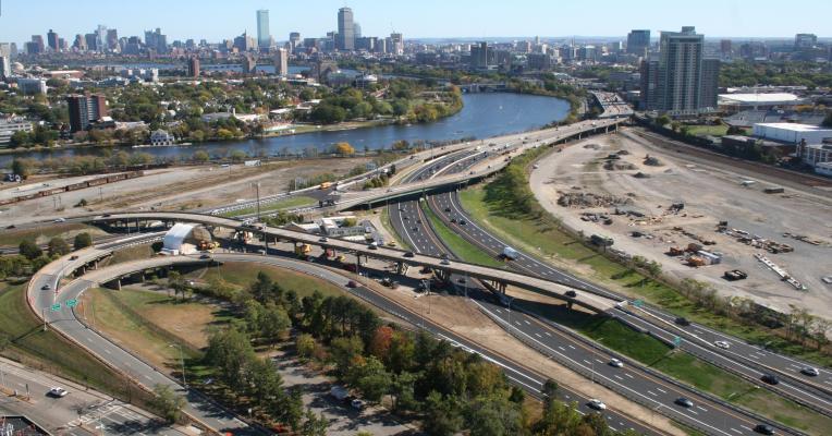
Around 90 acres of Boston’s Allston neighborhood will soon be transformed by the massive Allston Multimodal Project, which will bring some long overdue changes along the Charles River. The project will entail tearing down a crumbling highway viaduct nearing the end of its life, giving new life to an out-of-use commercial railyard, adding a new commuter rail station and providing nicer river paths for walking and biking. Sitting just across the river from Cambridge and a few minutes by train from downtown Boston, the site provides a once-in-a-lifetime opportunity to imagine and build an urban neighborhood and transportation network that can support Massachusetts’ ambitious goals to cut carbon pollution and promote sustainability.
One section of the existing site is a narrow corridor in which four train tracks, eight lanes of Interstate 90 and four lanes of the adjacent Soldiers Field Road run just feet from the river. The corridor is known as “the throat,” and in addition to the rail and roads, it also contains a well-used eight-foot bike and pedestrian path just feet from busy traffic. Because of the very constrained area between the river and the Boston University campus, there is extreme competition for space between transit, active transportation, parkland and highway. Yet the state of Massachusetts is currently planning to rebuild all existing lanes of traffic, reinforcing the region’s reliance on personal vehicles and reducing the project’s potential to deliver expanded access to clean and sustainable transportation.
Both the state of Massachusetts and the city of Boston have established goals for reducing carbon pollution and encouraging a shift away from reliance on personal vehicles that adds to congestion and reduces quality of life. Boston’s current climate plan calls for cutting carbon emissions 50 percent by 2030, and the state of Massachusetts set a net zero greenhouse gas emissions limit for 2050. Boston and Massachusetts have both set goals to shift transportation away from driving – Boston’s goal is to reduce the number of commuters who drive alone to work by 50 percent by 2030, and in 2012 Massachusetts set a goal to triple the share of people who walk, bike or take transit by 2030.
In its current form, the Allston project will do relatively little to achieve those goals. Instead it will:
- Maintain current vehicle capacity. The current construction plan will likely reduce capacity of the I-90 highway by at least two lanes for much of the eight to ten years of construction. Yet when construction is finished, the project will restore all 12 lanes of roadway along the river, in effect adding traffic capacity back to the city at the same time Boston is reaching its 2030 mode shift deadline.
- Prioritize driving over other forms of travel. MassDOT has suggested it may reduce rail capacity for some portion of the construction period, which could worsen the already-difficult commutes for both the adjacent neighborhoods and the commuters who travel via the corridor. Early versions of the project would have delayed the opening of the accompanying West Station commuter rail station for a decade after the highway was reconstructed. But MassDOT moved this investment to an earlier phase of the project following public pressure.
- Potentially limit future river access and expanded transit. As of October 2020, state officials were deciding between either building the new roads at ground level, or once again building a raised road viaduct – an option that would perpetuate many of the site’s existing problems. With a new viaduct, the project would continue to divide the Allston community and limit access to the Charles River’s bike and pedestrian path, just as the current road does. As a local coalition of environmental, business and transportation advocacy groups wrote in a letter to the Massachusetts Department of Transportation, a new viaduct would reinforce “the legacy of inequitable highway policies that tore communities apart decades ago.” A viaduct could also hinder the state’s ability to eventually build future passenger rail connections from West Station, including to Kendall Square in Cambridge, the heart of the region’s biotech industry.
The rebuilding of I-90 and other transportation infrastructure in Allston could improve life for pedestrians and bicyclists by replacing Soldiers Field Road with a surface street safe for crossing by foot and bike. It could help more people travel to the city without sitting in traffic by prioritizing construction of the new West Station, ensuring reliable transit service during construction and making possible more transit connections in the future. And it could finally allow local residents to safely enjoy access to the Charles River by substantially expanding open space. Yet in its current form, which is still being shaped as of this writing, whether the project will be able to fulfill even a fraction of this potential is an open question.
Unlike some other projects in this report, there is no escaping the need for major investment in transportation infrastructure in this section of Boston. The question is whether the commonwealth will invest in a bold, transformative plan that will help it meet its transportation and climate goals, or rebuild the auto-intensive infrastructure of generations ago, making it more costly and difficult to meet the transportation challenges of the 21st century.


