Survey Time in Alameda and Berkeley
Note: GJEL Accident Attorneys regularly sponsors coverage on Streetsblog San Francisco and Streetsblog California. Unless noted in the story, GJEL Accident Attorneys is not consulted for the content or editorial direction of the sponsored content.
The cities of Alameda and Berkeley have launched new surveys that Streetsblog readers should definitely take a few minutes to fill out.
Survey says: Alameda could add protected bike lanes on Grand
When it comes to street safety, the island city of Alameda has taken great strides, adding one of the first protected bike lanes in the Bay Area on Shoreline back in 2015. It’s continued to move forward with its cross-Alameda trail and a protected intersection and Otis and Grand. However, that protected intersection, great as it is, leads to unprotected, conventional bike lanes on Grand.
Thanks to the hard work of Bike Walk Alameda, city staff is now looking to take the next logical step, with its brand new survey about how to configure Grand Street:
Given the decades of crash data now collected on protected versus unprotected bike lanes, it’s crazy that this is even a discussion anymore: protected bike lanes should be the default whenever a street is repaved (on all but the calmest streets). Protected intersections and lanes make it safer for pedestrians too by shortening crossing distances.
However, that’s obviously not where the Bay Area is at just yet. That’s why Streetsblog urges readers to fill out this survey to ask for protected bike lanes on Grand.
Survey says: it’s time to update Berkeley’s bike plan
Speaking of protected bike lanes, Berkeley has been a real pioneer with its protected intersection at Hopkins and the Alameda and its great protective treatments on Milvia. But its overall bike plan is now five years old and is in need of an update. From a survey from the city that dropped earlier this month:
The current Berkeley Bicycle Plan was adopted in 2017, and now we are returning to the community in order to update that Plan. Should we change any recommendations from the 2017 Plan? What types of new recommendations would you like to see? Answering these questions and more will help the project team develop an updated bicycle policy framework that will ultimately guide the City’s priorities and decision making, all while making it easier, safer, and more comfortable to bicycle and roll in Berkeley. This update to the Bicycle Plan is scheduled for adoption in 2023.
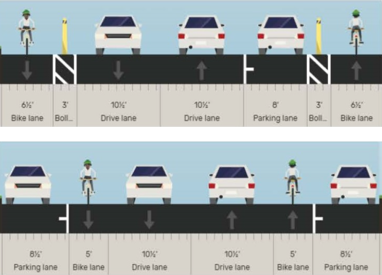
Be sure to fill out the survey and ask for more protected bike lanes and intersections in the update. On a closely related note, the advocates at Walk Bike Berkeley are urging supporters of safe streets to fill out this action item on Hopkins, asking for protected bike lanes along the entire street. Currently, the plan is for a precarious mix of protected and unprotected bike lanes, as seen in the image above.
The Hopkins Street design recommendations will make the street safer and more attractive for walking, biking, and transit by adding
- mostly protected bike lanes through the planning corridor
- pedestrian safety features (e.g., raised crosswalks at two locations, new stop signs at Hopkins & McGee)
- transit improvements (e.g., bus boarding islands)
However, these improvements shouldn’t end at Gilman! To further equity, safety, and sustainability, the City must extend the protected bike lanes to San Pablo when the road is repaved in 2023.
Be sure to fill out the action item/letter before May 10, when it goes before the city council.
And one last upcoming survey, this one in Fremont
Back in Sept., advocates made a last-ditch push to get the Fremont city council to vote for a road diet and safety measures on Paseo Padre Parkway. Unfortunately, the city council made it clear on Tuesday, by a six-to-one vote, that their priority is still car throughput.
From The Mercury News:
Despite what traffic engineers called “excessive ongoing speeding” along a winding and sloping portion of Paseo Padre Parkway, the Fremont City Council rejected a controversial proposal Tuesday to reduce the number of traffic lanes on the major road from four to two.
The majority of council members said they oppose reducing lanes along the roughly one-mile stretch of Paseo Padre between Driscoll Road and Washington Boulevard, which is lined with homes, largely because they are concerned about potential traffic congestion if lanes were removed.
Except with only 15,000 cars per day, the width of Paseo is inarguably excessive. The two lanes in each direction do only one thing: encourage dangerous speeding. And this is a street that goes past several schools. Nevertheless, Fremont Councilmember Jenny Kassan was the lone vote in favor of a safer configuration for the street.
So what’s the upcoming “survey” in Fremont? That’s the one that will be held on November 8, when the good people of Fremont can start booting their traffic-violence enablers out of office.
***
If Streetsblog has missed a traffic safety survey in your area, please post links in the comments section below.

Streetsblog has migrated to a new comment system. New commenters can register directly in the comments section of any article. Returning commenters: your previous comments and display name have been preserved, but you'll need to reclaim your account by clicking "Forgot your password?" on the sign-in form, entering your email, and following the verification link to set a new password — this is required because passwords could not be carried over during the migration. For questions, contact tips@streetsblog.org.