Note: GJEL Accident Attorneys regularly sponsors coverage on Streetsblog San Francisco and Streetsblog California. Unless noted in the story, GJEL Accident Attorneys is not consulted for the content or editorial direction of the sponsored content.
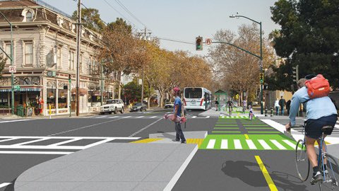
The Alameda City Council approved a $15 million safety project Tuesday evening for a little less than a mile of Central Avenue that will reduce lanes, slow traffic, and add a mix of buffered and protected bike lanes.
"We're very pleased with Council's approval of this long-awaited project," wrote Bike Walk Alameda's Denyse Trepanier, in an email to Streetsblog. "Although there's been delays over the years, each delay has resulted in a better project, with four roundabouts added with the latest incarnation."
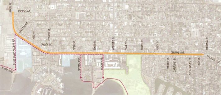
As seen in the map below, the project extends from Main Street to the intersection with Sherman and Encinal. A separate project, run by Caltrans, will eventually add buffered bike lanes on Encinal.
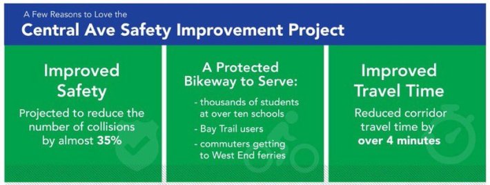
"Despite the 25-mile per hour speed limit, average speeds on this 1.7-mile corridor are over 30 miles an hour. Over a five-year period, prior to the pandemic, 63 collisions occurred on this public roadway... Twenty nine of these collisions resulted in injuries. Six collisions were between automobiles and pedestrians, and five were between automobiles and bicyclists," wrote Alameda staffers in their documentation explaining why upgrades are needed.
Some 34 speakers came to Tuesday's meeting to speak in favor of the new plan. "A big shout out to all of you who showed up and spoke!" wrote Bike Walk Alameda's Patricia Potter on social media.
Some Streetsblog readers may take issue with the fact that there are still unprotected bike lanes east of Eight Street. Or that the city picked a two-way cycle track, rather than a protected bike lane on both sides of the street, from Eight to Main. As previously reported, two-way protected bike lanes, while a great improvement over unprotected lanes, are still less than ideal on city streets.
But Bike East Bay's Dave Campbell says that misses the point of Alameda's plan and what advocates were up against a decade ago when the process began. "Shoreline Drive had just been done, so now we had a two-way cycle track almost all the way to 8th and Central... the idea was to continue Shoreline's family friendly facility on down to Main Street."
Two-way cycle tracks make sense on a shoreline or anywhere else where intersections are not an issue. And with the progress Alameda is making, points out Campbell, the city is edging ever closer to having that "family friendly" protected facility ring the entire island. "I'm satisfied with the progress we've made."
As to the portion that lacks protection, Alameda's Senior Transportation Coordinator, Gail Payne, said it "...has to do with the number of driveways in the area east of Eighth Street as opposed to the lack of driveways to the west of Eighth Street. Streets with fewer driveways are easier to transform into two-way bikeways due to the lack of conflicts." Easier, for sure--and this is a common response from Bay Area planning officials. But frequent driveways do not rule out protected bike lanes, as Streetsblog has pointed out multiple times and the Bicycle Dutch blog has documented on video.
As for the roundabouts, as indicated below they reduce collisions and are rapidly becoming a more common and accepted safety tool used by Bay Area planners. It's important that there is a separate lane for cyclists through the roundabouts, which Alameda's planners seem to have incorporated going by the schematics.
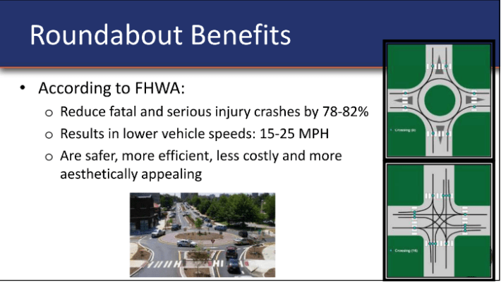
"The easternmost roundabout at Sherman was controversial for some in that it proposed to close off Sherman to the south, creating a cul-de-sac for that street. Council ultimately settled on an alternate design. Recognizing that it wasn't the ideal option, they included a caveat that they may seek funding to purchase a right-of-way for more room--and design flexibility--at that intersection," said Trepanier.
She had no caveats, however, about her support for the overall project. "This will close a critical gap in our safe network for folks commuting to schools and our new ferry terminal at Seaplane Lagoon outside of cars. Over 4,000 kids go to school along this high injury corridor, and we're thrilled that the majority of our Council has prioritized safety for our kids. This project is actually also a win for drivers with expected reductions in both drive times and crashes through this corridor."
Construction is expected to start late next year.