This piece originally appeared on City Fix and is reprinted here with permission.
As the COVID-19 pandemic has altered urban landscapes and pushed many people toward active mobility, there’s increased urgency to make roads safer for walking and cycling. Many cities are now tasked with protecting more vulnerable users in addition to creating safe public spaces that will enable economic recovery and allow residents to enjoy the outdoors. At the same time, there are long-term reasons to support this transition.
“Walking and cycling are among the most sustainable ways to get around cities – but not if they are extremely dangerous,” said?Claudia Adriazola-Steil, Acting Director of Urban Mobility and Director of Health & Road Safety at WRI Ross Center for Sustainable Cities.
Traffic crashes remain a leading cause of death worldwide, and the number one cause of death and serious injury for young people aged 5 to 29. Speed is one of the main risk factors in road crashes; in low- and middle-income countries, in particular, vehicle speeds are the leading factor in almost half of all traffic fatalities. Even small increases in speed significantly increase the probability of death or injury.
But we know what works. Low-speed zones are a key solution for effective speed management. A low-speed zone is a defined area – such as a school zone, neighborhood or commercial district – that aims to improve the safety of vulnerable users through traffic-calming measures. And by supporting safe active travel, these zones reap a variety of other benefits, ranging from better air quality, to economic recovery to broader sustainability.
A new guide by WRI and the World Bank sets out guidelines for planning, designing, implementing and evaluating low-speed zones. Below are examples of design considerations for low-speed zones in diverse settings to help create safer, thriving urban spaces.
1. High-Density, Mixed-Use Streets
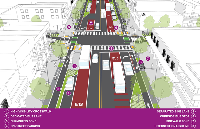
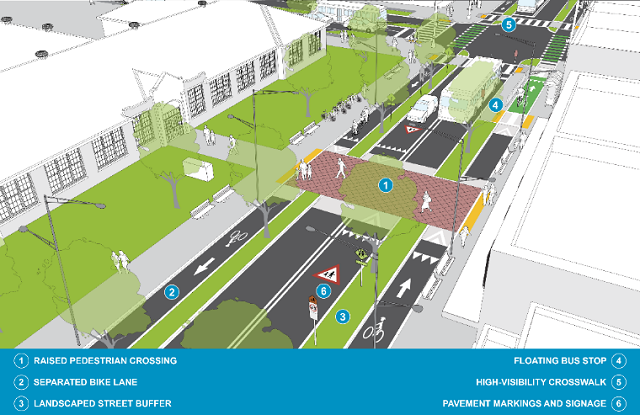
High-density, mixed-use streets are hubs of activity and community interaction and are often traffic-dense. Therefore, prioritizing the comfort and safety of vulnerable users over motorists should be the goal here. These streets must provide adequate and clear separation between transport modes to ensure safety for the most vulnerable, like pedestrians and cyclists, while allowing smooth traffic flow.
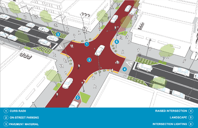
Target speeds for these streets are 20-30 km/h, and it’s important to provide both visual and physical cues to encourage drivers to slow down. Examples include elements that narrow lanes and slow vehicles at key points, such as center medians and curb radii less than 4.5 meters.
In addition to slowing speeds, the visibility of pedestrians and cyclists should be increased through high-visibility crossings, and pavement markings that extend through intersections and at midblock crossings where needed. Other design elements, like street furnishings, can further promote pedestrian and cyclist priority and foster social, economic and cultural activity.
2. Residential Streets
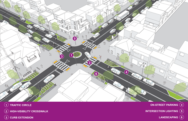
Residential streets should provide safe, accessible spaces for social interaction and frequent travel by all types of users. These streets should focus less on traffic flow and more on providing a safe environment for families walking around the neighborhood or children playing on the roadside. These streets function best with an assigned target speed of 20-30km/h, but generally have less traffic density and fewer vehicle types.
Wide sidewalks, layered planting of trees and shrubs, and appropriate street lighting improve overall pedestrian comfort, walkability and safety. As with other street types, it’s important here to visually and physically narrow the roadway for drivers to encourage slower speeds. One of the many ways to do this, especially in a residential setting, is to accommodate on-street parking. Not only does this improve accessibility for residents, it helps with “perceptive” narrowing of streets and creates a buffer zone between bike lanes or sidewalks and vehicular traffic.
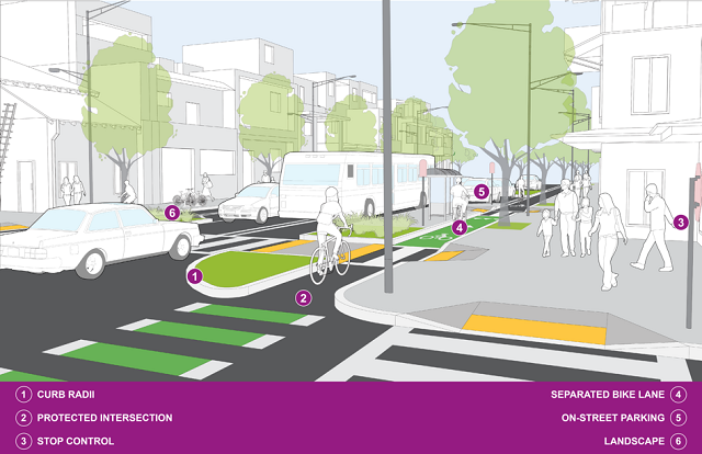
For safety at intersections, street space and crossing locations should be clearly designated for each transport mode. Access to public transportation should also be carefully considered and accommodated through bus stops and public bike-share docking stations or parking areas that allow safe and efficient queuing, boarding and docking. Bus stops, driveways and intersections are locations that frequently generate conflicts between cyclists and other road users. These areas should be designed to improve visibility and easily convey which user has the right of way.
3. School Zones
Slowing speeds near schools is crucial. The number of children injured or disabled as a result of road traffic crashes is estimated to be around 10 million each year. Children are more vulnerable to collisions than adults due to their size, limited impulse control and slower reaction time.
Speeds in a school area should be no more than 20km/h. Streets must be equipped with visual, physical and regulatory cues such as traffic signs, high-visibility and raised crossings, curb extensions, and detectable road markings that alert drivers to the presence of children and reduce their speeds. Children are often obscured by parked cars, tall landscaping and other street elements, so sightlines are also important to consider. Parking restrictions near crossing locations should also be considered to reduce overall vehicle traffic.
SARSAI, the winner of the 2018-2019 WRI Ross Center Prize for Cities, implemented many of these elements to help reduce traffic injuries among children in Dar Es Salaam, Tanzania, and other African cities by 26% through targeted interventions in school areas.
4. Shared Streets
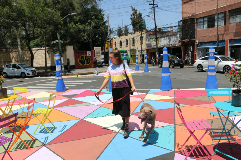
Shared streets comingle pedestrians, cyclists and vehicles in the same space and work best in commercial areas with high pedestrian traffic, allowing easy access to commerce and essentially expanding public space into the street. Low vehicle volumes and speeds not exceeding 10km/h are essential here.
Shared streets generally do not have vertical curbs, signs and as many pavement markings that clearly segregate modes. Instead, raised intersections and texture changes are used to mark the transition to a shared street. These design cues help all users advance with caution and practice safer vehicular speeds in the zone. The use of street furnishings, public installations and lighting also adds functionality and vitality. Data from the Netherlands indicates that well-designed shared streets can reduce the incidence of crashes by up to 50%.
At the same time, it’s important to realize the added concern this type of street could impose on the disabled community and the need to design shared streets mindfully for those with vision and mobility impairments, including with elements like tactile walking surfaces, readily detectable edges and warning surfaces, and audible information at key areas like crosswalks.
As the above examples show, the most important first step in designing a low-speed zone is assessing existing road conditions and context. What best fits the purpose of the area and users? Then, speed-calming solutions that suit those conditions can be implemented to accommodate all street users safely, comfortably and efficiently. Choosing the right set of traffic-calming interventions within an identified zone can make all the difference in saving lives, as well as creating more accessible, livable urban spaces.
This week marks the 6th UN Global Road Safety week. Join WRI and the World Bank on May 20 at 9am EDT to officially launch the Low-Speed Zone Guide and discuss an upcoming comprehensive Global Speed Management Guide for policymakers. Register here.
Nikita Luke is a senior project associate for health and road safety at WRI Ross Center for Sustainable Cities.
Siba El-Samra is an urban mobility associate for health and road safety at WRI Ross Center for Sustainable Cities.
