Caltrans and Solano County broke ground last month on the Bay Area's first "diverging diamond" interchange. From the release about the project:
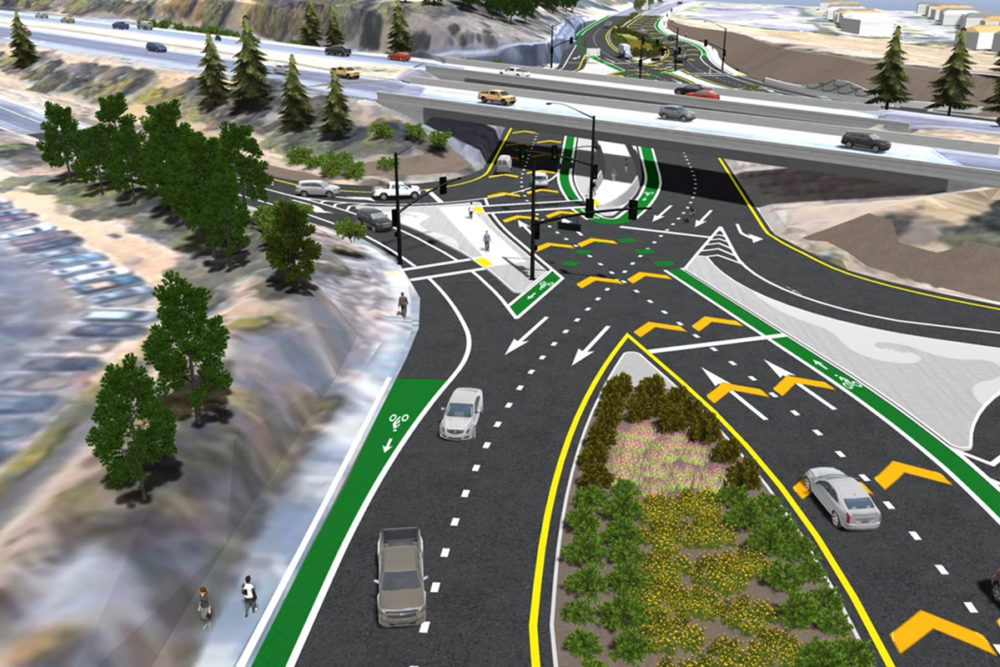
The Solano Transportation Authority (STA), in partnership with the City of Vallejo, Caltrans, and Solano County, is leading construction on the State Route 37/Fairgrounds Drive Interchange Improvements Project. This project will include roadway improvements along portions of Fairgrounds Drive and Redwood Parkway/Redwood Street, as well as several nearby intersections and interchanges within the City of Vallejo. Specifically, this project will widen and improve 1.5 miles of Fairgrounds Drive, extending from the State Route 37 interchange to the Redwood Parkway/Interstate 80 Interchange. The project will implement a Diverging Diamond Interchange design that will significantly improve traffic flow and safety, while reducing congestion and greenhouse gas emissions. At the end of the project, it will be both safer and easier for motorists, pedestrians, and cyclists [emphasis added] to access and navigate.
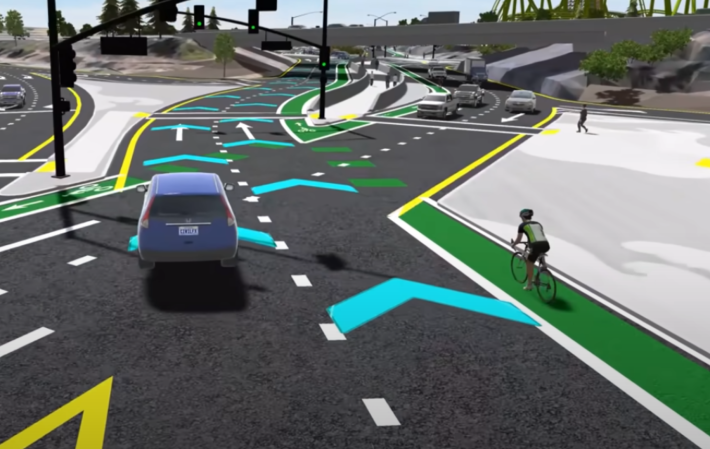
It's that last part that sticks in the craw of advocates—one just has to look at the magic green, car-stopping safety paint in the lead image to see why (if you still don't see why, have your kids ride a bike in that green space with cars whipping by at freeway speeds). Advocate and Livermore City Councilperson-elect Steven Dunbar put together this comprehensive list of reasons why the design is not, in any way, shape or form, safer for cyclists. As he pointed out in an email to Streetsblog about critiques of the diamond and the rest of the surrounding ramp and road project, which shows:
- 4' bike lanes (including the gutter pan) reduced from currently 6' due to a median widening along a roadway with a speed limit of 35mph and an 85th percentile speed almost certainly higher than that, in direct contradiction with the Manual on Uniform Traffic Control Devices (MUTCD)
- 5' bike lanes directly along 3 lanes of 35mph+ roadway traffic
- an environmental impact report that claims an unprotected bike lane fulfills the goals of a planned protected bike path and therefore does not need mitigation
- long "floating" exposed 5' bike lanes between through and onramp-bound 14' general travel lanes where a transit bus also merges across
- bike lanes which are marked diagonally across dropped right turn lanes, in direct contradiction with MUTCD
- bike lanes which gradually cross shallow angle freeway ramps (southbound from the north side) which is a misuse of the low-angle bike lane MUTCD guidance
- bike lanes which become sharrows in the furthest right turn only lane adjacent to an optional 2nd right turn lane, in contradiction with MUTCD
- an apparent 2-stage bike turn that doesn't allow any passing space for a second cyclist to go by a waiting cyclist
- a lack of bicycle conflict dashed markings at multiple ramp crossings
- misplaced bicycle stop bars such that bicycle non-detection or trapped bicyclists in the mid-intersection will be a problem
- a failure to build a pedestrian route on the southeast side of the interchange, requiring 5 crosswalk crossings where 3 are currently required (with 1 crosswalk twice as long any previously required)
- an extremely large increase in turning radius at Sage Street which will decrease pedestrian safety from the prior layout
- an extremely narrow pedestrian waiting area at the northeast corner facing traffic whizzing by in both directions
- the continued misuse of non-directional curb ramps in conflict with the American with Disabilities Act.
- dramatically expands crossing distances at most crosswalks
- relocates a bus stop to the far side of an intersection, now requiring 2 crosswalks to cross to the north Six Flags entrance
- the removal of recently installed bus stops on the on-ramps, replaced by a single bus stop for both directions
- the requirement for the through-running SolTrans route to make U turns at adjacent intersections to service the area, adding substantial delay to the through route
- the requirement for a bus operator heading west to merge across an uncontrolled onramp, a bike lane, and 2 travel lanes to get back onto the freeway
To encapsulate: "diverging diamonds are just another car-brained traffic engineer 'innovation' with tunnel vision only for moving as many cars as possible, with little consideration for where people are going *to*, Vehicle Miles Traveled, active transportation and transit, etc.," wrote Bike East Bay's Robert Prinz in an email to Streetsblog.

Prinz cites the Gilman Street project in Berkeley of an example of how to build an exchange that actually does help people on bikes and on foot. He explains that the diverging diamond in Vallejo, as well as many of Caltrans cloverleaf and other designs, impose nearly quarter-mile crossing distances on pedestrians. "Compare that to the new double roundabout interchange on Gilman Street in Berkeley which has a surface level crossing distance of only about a tenth of a mile with almost no waiting, creating a significantly lowered barrier for people outside of cars."
Despite that, Dave Ambuehl, the chief deputy district director of Caltrans, told SFGate of the Vallejo project that “Together we’re advancing initiatives focused on creating safer, more efficient travel options for all modes of transportation, from vehicles to bicycles to pedestrians.”
Diverging diamond interchanges are like the hyperloop or AVs as solutions for “fixing” traffic, in that they all fundamentally misunderstand that the core issue is improving land use & reducing vehicle miles travelled, not moving more cars further.
— Robert Prinz (@prinzrob.bsky.social) 2024-11-25T01:43:15.745Z
Of course, as Dunbar and Prinz point out, it doesn't do anything Ambuehl is claiming. And for cyclists especially this is a just another state-funded meat grinder—not that many people on two wheels will be suicidal enough to ride it, unless they absolutely have no choice. And for pedestrians, it's an absolute rats maze that will deter walking even more than Caltrans's current designs. From Streetsblog's view, this is just more evidence that Caltrans continues to employ, mostly, incompetent, deceitful dinosaurs who don't know how to build safe infrastructure and don't care to learn.
The Vallejo project will cost $25 million and take about a year to complete.


